We weren’t sure if Perspectives would make it through to version 3, but with this proof of concept, I think it’s clear it’s worthwhile. More detail in another post.

We weren’t sure if Perspectives would make it through to version 3, but with this proof of concept, I think it’s clear it’s worthwhile. More detail in another post.
More Dungeon Symbols

Well of Elemental Water
I’m very happy to report that Joseph Sweeney has taken to Cosmographer 3 like an angry Rancor to Jabba’s fighting pit and produced his first video tutorials for our sci-fi add-on. Continue reading »
Note: This is a cross post. The original is posted @ The CC3 Developer Blog
Wow, its been a while since I’ve written a post here. The holidays are always a busy family blur. Well, here is the latest installment …
The path/poly element is the most used element in CC3. You really cannot get much done with it. Try building anything in CC3 without it (Sure you can just use more primitive elements and use multipoly & group for joining and filling, but really you are just re-creating the path/poly element). So if you want to get something done in an XP, odds are you are going to be working with paths/polys.
 Here is the follow-up to our poll asking which additional Traveller starship deckplans we should do. I was a bit surprised that warships seemed to be the top choices (except for the far trader). I’d have thought that civilian ships would be more important to most Traveller players.
Nevertheless we created deckplans for the three most popular designs:

The January issue: A new drawing style
If you are already a ProFantasy Software customer, you now having something to put on your wish list – a ProFantasy Gift Voucher. You don’t need to be told what you can get – you already know!
This post is for people with roleplayers or map-makers in their lives other than themselves, so you’ve got an idea what your recipient can get with their gift voucher. And your recipient can combine vouchers, so that a game group can all chip in.
Because we like to be classy, our vouchers do not expire, unlike certain others. After all, we still offer downloads for ten-year-old orders.
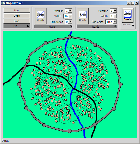
As Simon mentioned in a previous post here, I am working on an application, which I am developing under the code name “Map Invoker”. It will generate random towns, from small little hamlets to large walled cities. I’ve been concentrating on the algorithm side and am truely quite a ways towards a “feature complete” logic set.
So Simon was correct in stating that “He’s gone beyond proof of concept”. Soon I will be turning from generation to the interface so that all the parameters that I’ve included in the algorithms are exposed to the user so that the user can create an incredable range of different towns.
Once the parameter inputs are down and tested, then we will be looking into adding all the “garnish” that makes programs like this come alive.
So if you have any ideas, practical or “pie in the sky”, I’d love to here them. Either post your idea or email me at: SAUNDERL (at) HOTMAIL (dot) COM.
L Lee Saunders is working on a random city generator for CC3. Lee has worked with ProFantasy for many years, producing features such as the fractal path and text around a curve. He has an excellent development blog for people who want to create CC3 add-ons, which he will mirror here.
The Random City Generator will be included in a future version of Campaign Cartographer or City Designer, or be available as a separate product. He’s gone beyond proof of concept – here is a screen shot. It already does basic CC3 import using the House command, and we’ll be reporting on its progress regularly.
Each year in October a medium-sized city in Germany’s Ruhr area becomes the mecca of boardgamers around the world: The “Internationale Spieltage SPIEL 2010” or “Spiel” for short open its doors.