ralf | April 1, 2015 | black and white, Par lindstrom, town, Village
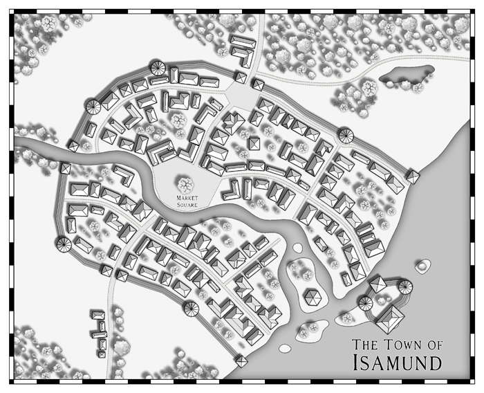
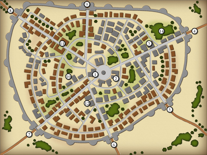
 The Annual’s April issue is here on time (and totally without a prank), with another beautiful black and white drawing style by Pär Lindström. This time he gives us the tools and artwork to draw town and village maps in a beautiful, but still easy style. As always you can download the “Black and White Towns” style from your registration page.
If you haven’t subscribed to the Annual 2015 yet, you can do so here.
Comments Off on Cartographer’s Annual: April Issue
ralf | February 2, 2015 | Annual, Lighting, Tutorial
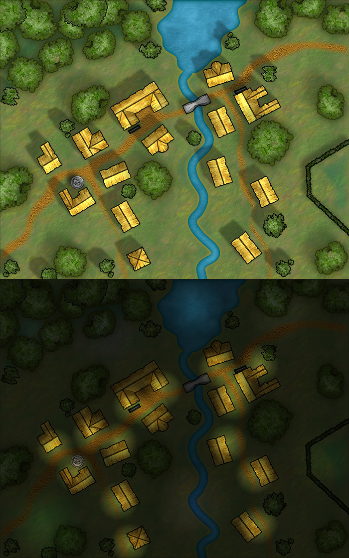
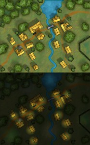 It’s easy to overlook the small things, with the big release of CC3+ last week, but we should not forget it’s a new month and a new Annual issue is available: The Tutorial Pack – Day and Night. If you are a subscriber, you can download it from your registration page.
This tutorial takes an in-depth look at creating differently lighted environments, for example if you want to show a combat encounter area in both daytime and nighttime conditions.
If you haven’t subscribed to the Annual 2015 yet, you can do so here.
Note on CC3+: For now this Annual issue is done for CC3, as the CD3 and DD3 add-ons are not updated for use in CC3+ yet. Starting next month, we’ll make the Annual issues available in both CC3 and CC3+ versions.
Comments Off on Cartographer’s Annual 2015: February Issue
Simon Rogers | November 25, 2014 | Pelgrane
Pelgrane Press, ProFantasy Software‘s sister company makes tabletop RPGs, and as such has a burning need for cartographic resources, so of course we take advantage of the connection. We’ve collaborated on a number of projects in a number of styles – styles we’ve then bought to our users. The latest such colloboration will be The Dracula Dossier – a Kickstarted project featuring spies versus the greatest vampire of the them all, for which Ralf will be creating maps. Back it here.
So, here are some of the other projects we’ve worked on together.
Created by Pär Lindström and designed for the the Pelgrane Trail of Cthulhu adventure collection Mythos Expedition the style lets you depict the itinerary and visited locations for journeys or expeditions as would be found in horror or pulp adventures.
“>
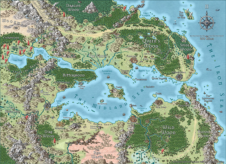
The September issue of the Annual 2012 contains a new overland style based on the gorgeous world map of the upcoming role-playing game 13th Age by Rob Heinsoo and Jonathan Tweet. The style was developed by Lee Moyer.
“>
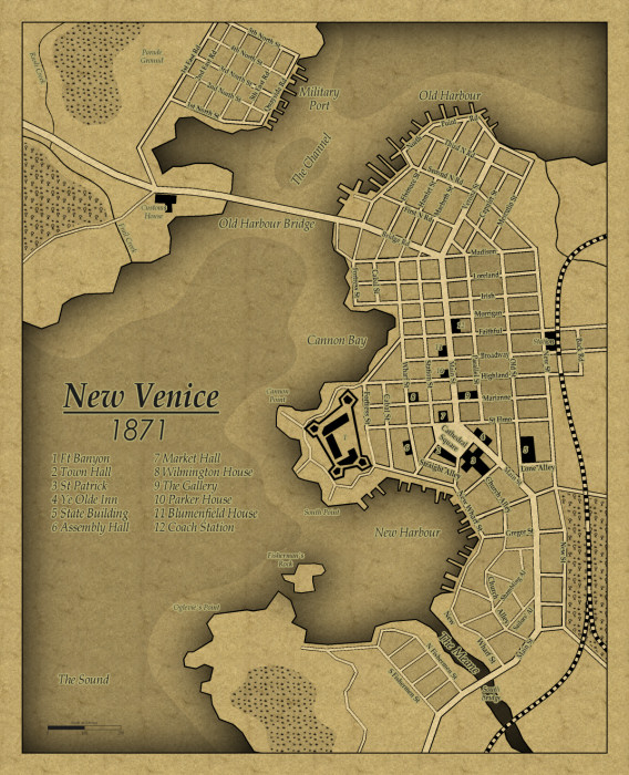
The December Annual 2011 brings you a companion style to April’s 1930s floorplans: city maps in the same Baedeker travel guide style for your modern horror and pulp-style games. Pelgrane Press used this in Arkham Detective Tales Extended Edition.“>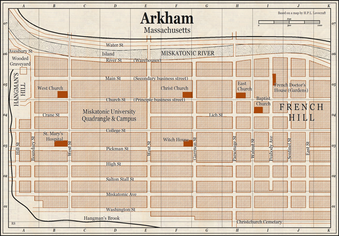
Ralf Schemmann recreated the 13th Age map in the Mike Schley overland style included with the forthcoming cc3+.
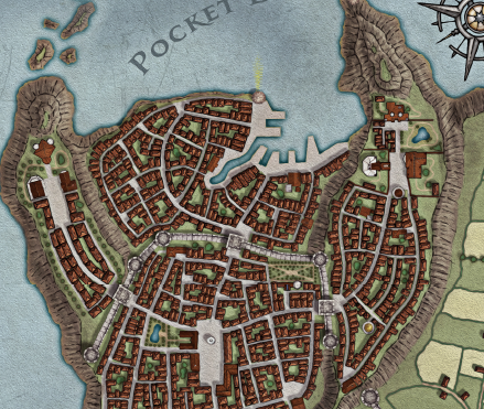
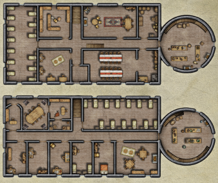
Pär Lindström created a city map and floorplans for the 13th Age city adventure Shadows of Eldolan using CC3, City Designer 3 and the Symbol Set 4: Dungeons of Schley style. He did some post work on the city map in Photoshop
Comments Off on Pelgrane, meet ProFantasy
ralf | November 21, 2014 | user maps
It’s been a while since we posted a round up of user maps, mostly because we are very busy with CC3+ and had the summer’s convention schedule to take care of. But that doesn’t mean there haven’t been great maps posted to the forum – quite to the contrary as you can see below.
You can always rely on Grimur to take everyone’s breath away with his gorgeous maps, like this one using the Herwin Wielink overland style.
Continue reading »
2 Comments
Simon Rogers | June 13, 2014 | Annual, city design, examples
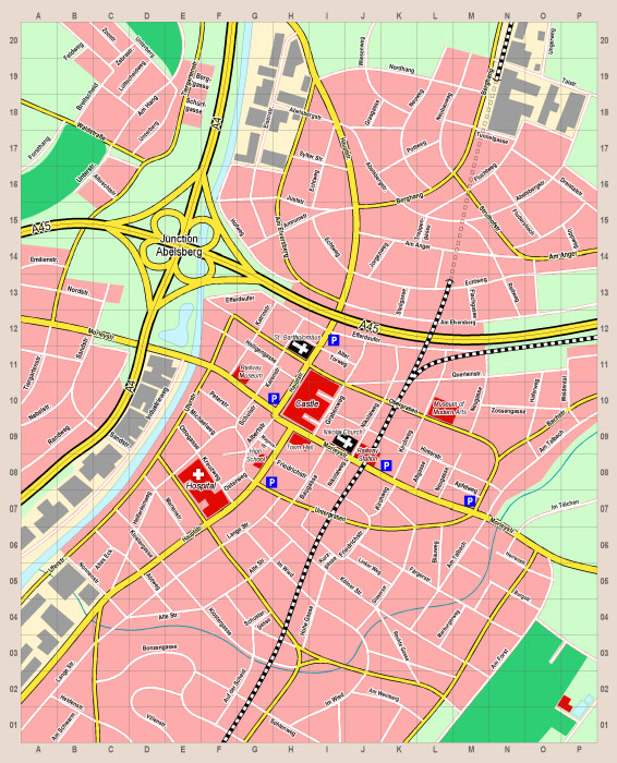
You can create a wide range of cities and urban areas with CC3 and its add-ons and symbol sets. This article shows you a selection, and the software you need to create them.
City Designer 3 is (unsurprisingly) the best resource for urban areas – the following examples were created with CD3.
This is from the Annual Vol 5 – a 1930s style map.
a This map was created with the black and white city style released in the Annual Vol 4
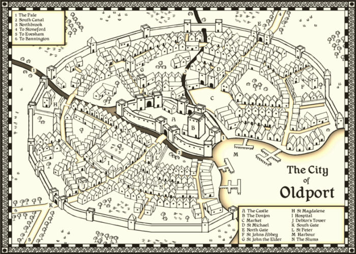
Two styles in one, here in the Annual Vol 1. One is remininiscent of 18th to 19th century maps, while the second creates the look of contemporary street maps.
This map emulates the famous town and city maps of British cartographer John Speed (1542-1629). It was created with the John Speed City style from The Cartographer’s Annual Vol 1.
This style from the Annual Vol 3 does not require City Designer 3
Comments Off on Making City Maps with CC3
ralf | February 19, 2014 | community, Maps of the Month, user maps
It’s time for the monthly parade of user maps posted to the ProFantasy forum – again we have some lovely work to show off, thanks to the community!
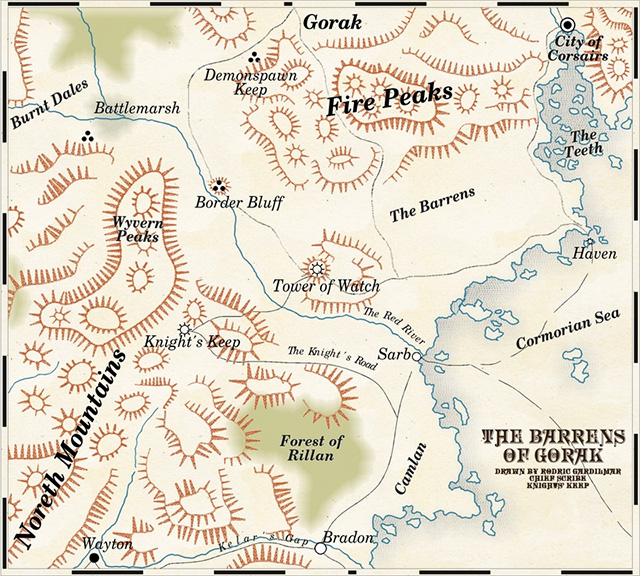
As described elsewhere, TolrendorDM finished off his 2013 Annual Challenge with this map of the “Barrens of Gorak” in the 1930’s travel guide style.
Continue reading »
Comments Off on User Maps of January
ralf | March 19, 2013 | community, Maps of the Month, user maps
It’s time again to admire all the user maps that have popped up in the ProFantasy forum during the last four weeks.
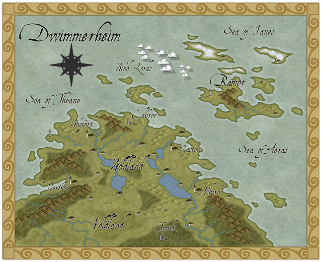
Taking up a recent Annual issue (Pär Lindström’s regional style), Modric created this beauty of the Dwimmerheim region.
Continue reading »
1 Comment
Simon Rogers | February 18, 2013 |
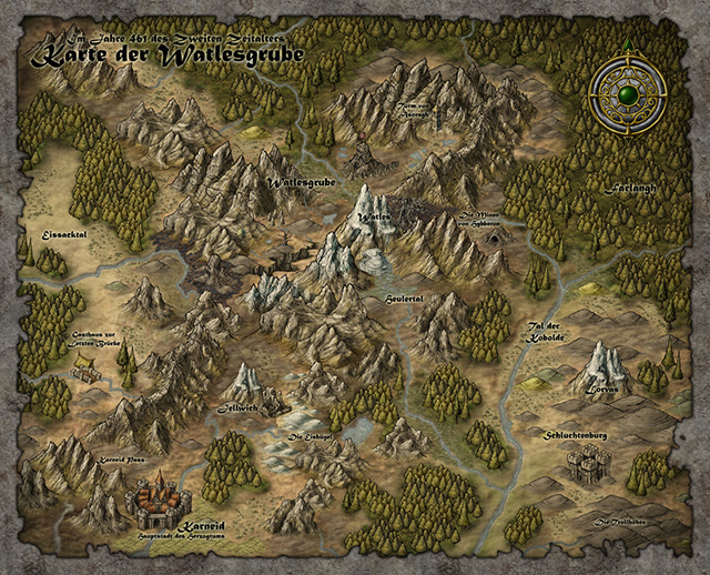
One of the things I like most with making maps is when you have to decide where your different countries and cities will be placed. But how can you do this in a convincing way? Where shall you put your cities? As always we have to look at our own history and learn.
If you look back in our history nearly all early cities started out close to water. Before we had good roads waterways were the highways for travel and transportation. To be able to start up a city you needed a surplus of goods and food, so not everyone needed to work. So that some people in the community could start doing the administrative tasks to keep it all together. Living close to water made those things easier to happen.
When that happens a smaller tribal village can evolve into something larger, a city, and in the end a great kingdom or empire. Of course this description is very simplified, but still you can say that this is the foundation behind the growth of a society. Maybe you have to add in things like learning to write, minting coins and technological advancements in building techniques. But without a surplus in production those other things will never kick off.
So how can you use this knowledge in your mapping?. Well when I make my maps I usually wait to plot out borders for countries and their cities until all the terrain is done. When the terrain is done I try to locate places in the map where larger cities might lie. If you look at the example map below I’ve marked out some locations with red circles. Those places are where I probably would put the larger cities in the map.
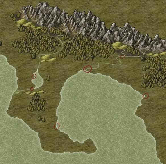
But not all cities are located close to water, so where should you put the rest of the cities?. To find out this the next thing to do is to draw roads between the large cities. When you’re done have a look at the map for crossroads, crossroads are typical places for a city or town. A place where people travelling to and from different locations meet, and goods can be sold. In the example map below I’ve added some roads and cities at the crossroads.
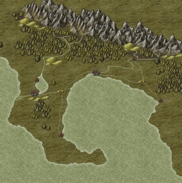
We now have a good base for our kingdom with some logically planned cities and towns. Next step is to continue adding in more towns, but this time towns that might not feel logically placed in the beginning. When a kingdom continue to evolve other more rare resources gets more and more important, like gold, silver, iron etc. Try to add towns in places close to where they can acquire resources for the kingdom. Also think of how the goods will be transported to the main towns. If you place a small town in the mountains where they mine silver and you have a river close by they would probably found another town next to the river so they easily can transport the silver, instead of transporting it all by the road. In the example map below I’ve added in some towns where they can collect resources.

You can continue this way and add in more and more towns. After adding the towns you add in more roads, more roads means more crossroads that leads to more towns. If you try to build up your map this way the placing of your towns will feel logical which will give you a better and more believing map. And while mapping you might even come up with an idea or two for an adventure.
Reposted from mapping worlds.
1 Comment
ralf | January 30, 2013 | community, Maps of the Month, user maps
We’ve gone into 2013 and our community shows no sign of letting up with the barrage of wonderful user maps. Here’s the roundup for January!
KenG was inspired by KROM’s wonderful close-up maps/paintings done in the Herwin Wielink overland style. The result is this beautiful local map.
Continue reading »
1 Comment
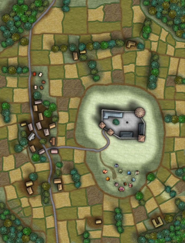
Clercon | January 30, 2013 | CD3, Par lindstrom, Village
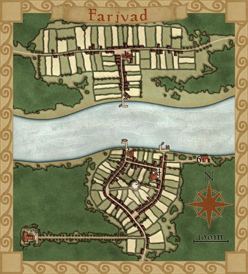
This is my latest map made in City Designer 3 (CD3), plus some effects added in Photoshop. It depicts the village Farjvad in the province Vadsbro and is part of the campaign/adventure I’m working on at the moment, even though I’ve mostly made maps so far.
Farjvad is situated about a day’s trip north east of the main town in the area, Vadsbro. Farjvad won’t actually be of importance for the adventure I’m writing, but it will still be a part of the campaign information. As you might have noticed I like to make maps, and making the adventure/campaign gives me some good reasons to do that. I also figured out that if I only have maps of the villages where the adventure takes place the players will rather quickly figure out what places are of importance and which ones are not. Also this will make the adventure feel much more unscripted if the players can go wherever they pleasein the area and the GM will have a nice map of the place.
So how did I go from a blank page to a finished map? What shall you think about while making a village map? First of all you have to decide where the village is situated, is it in a forest or a desert? The environment gives as well takes away possibilities for the map. In my case I know from the overland map of the province Vadsbro that Fjardinge is a village that is founded on two sides of a river, only connected via a ferry in the middle of a large forest.
I also decided that the south part of the village was the old one and that the north side is the new part where recent expansion of the village has taken place. Because that the village is situated in the middle of the forest there had to be some place for the villagers to go for protection if some kind of crises turned up. In this case I put a keep (nr 5 on the map) where the governor of the village used to live with his soldiers, maybe ten of them at a max. I could have gone with a palisade but in this case it didn’t feel right.
I also added a temple (nr 4), all places must have somewhere to go for religious need. The ruined temple (7) just outside the village was deserted when the new temple was done. What resides there today is up to the GM to decide.
Nowadays most travelers are using the northern road that leads from Vadsbro to the village Klyvholm. For this reason a newer part of Fjardinge has been built on the northern side. To make the sides differ a bit I decided to make the fields more square here, like they’ve been planned a bit. The big house at the square (nr 1) will also house the governor of the village (he decided to move here from his keep on the south side).
What I’ve actually have done here is making a story around the village and letting the story lead the way while mapping. I think I’ve stated this before but having a story in your head while mapping usually makes your maps more interesting, which means a better end result. It is also a lot more fun to map when you have a picture in your head of what the place looks like, it is like seeing your ideas come to life.
Originally posted on mappingworlds.wordpress.com
Comments Off on Farjvad
 The Annual’s April issue is here on time (and totally without a prank), with another beautiful black and white drawing style by Pär Lindström. This time he gives us the tools and artwork to draw town and village maps in a beautiful, but still easy style. As always you can download the “Black and White Towns” style from your registration page.