This is my latest map made in City Designer 3 (CD3), plus some effects added in Photoshop. It depicts the village Farjvad in the province Vadsbro and is part of the campaign/adventure I’m working on at the moment, even though I’ve mostly made maps so far.
Farjvad is situated about a day’s trip north east of the main town in the area, Vadsbro. Farjvad won’t actually be of importance for the adventure I’m writing, but it will still be a part of the campaign information. As you might have noticed I like to make maps, and making the adventure/campaign gives me some good reasons to do that. I also figured out that if I only have maps of the villages where the adventure takes place the players will rather quickly figure out what places are of importance and which ones are not. Also this will make the adventure feel much more unscripted if the players can go wherever they pleasein the area and the GM will have a nice map of the place.
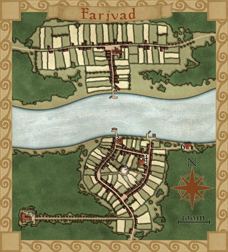
So how did I go from a blank page to a finished map? What shall you think about while making a village map? First of all you have to decide where the village is situated, is it in a forest or a desert? The environment gives as well takes away possibilities for the map. In my case I know from the overland map of the province Vadsbro that Fjardinge is a village that is founded on two sides of a river, only connected via a ferry in the middle of a large forest.
I also decided that the south part of the village was the old one and that the north side is the new part where recent expansion of the village has taken place. Because that the village is situated in the middle of the forest there had to be some place for the villagers to go for protection if some kind of crises turned up. In this case I put a keep (nr 5 on the map) where the governor of the village used to live with his soldiers, maybe ten of them at a max. I could have gone with a palisade but in this case it didn’t feel right.
I also added a temple (nr 4), all places must have somewhere to go for religious need. The ruined temple (7) just outside the village was deserted when the new temple was done. What resides there today is up to the GM to decide.
Nowadays most travelers are using the northern road that leads from Vadsbro to the village Klyvholm. For this reason a newer part of Fjardinge has been built on the northern side. To make the sides differ a bit I decided to make the fields more square here, like they’ve been planned a bit. The big house at the square (nr 1) will also house the governor of the village (he decided to move here from his keep on the south side).
What I’ve actually have done here is making a story around the village and letting the story lead the way while mapping. I think I’ve stated this before but having a story in your head while mapping usually makes your maps more interesting, which means a better end result. It is also a lot more fun to map when you have a picture in your head of what the place looks like, it is like seeing your ideas come to life.
Originally posted on mappingworlds.wordpress.com