ralf | April 15, 2013 | Annual, Jon Roberts, kobold press, midgard, overland
We have released the April issue of the Cartographer’s Annual 2013: The Midgard World overland style. Created in cooperation with Kobold Press and Jonathan Roberts, this style recreates the maps published in the Midgard fantasy campaign setting and the accompanying iPad atlas. You can now add your own regional maps for this setting, or recreate another world in the same mapping style.

Even better, the Midgard World style is compatible with the Jon Roberts overland style from the Annual Vol 5. They can be combined for a greatly enlarged variety of symbols and fill styles.
Comments Off on Cartographer’s Annual: the Midgard World style
ralf | March 1, 2013 | Annual, overland, user maps
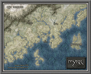
We’ve just released the March Annual issue: Flavio’s Myrr Overland style is now available as a download for the Annual subscribers.
His beautiful and unique overland style is based on intricate bitmap texture and shaded contours, as you can see from this sample:
You can subscribe to the current Annual here.
Comments Off on Cartographer’s Annual: Myrr Overland style released
ralf | February 28, 2013 | giveaway
Forum member Gonzalo (pool7) has some spare ProFantasy products that he is generously giving away to the community. Post in this thread on the forum to get a chance to win a Symbol Set 1, an Annual Vol 4 or Vol 5 or a Tome of Ultimate Mapping.
2 Comments
Simon Rogers | January 30, 2013 | Newsletter
 A little late for January, perhaps, but here is the latest newsletter.
News
Resources
Map-Making Articles
[poll id=”5″]
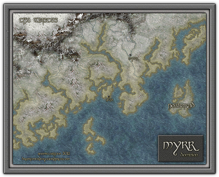
Look at the Myrr Dominion map here.
Comments Off on The January Newsletter – New Year, New Styles
Simon Rogers | January 30, 2013 | effects, overland, Tutorial
[Ed’s Note: Let us know if you like this style, and with Flavio’s permission, we’ll create an Annual from it]
My fiancée recently asked me if it would be OK to make a Viking character for my Al-Qadim campaign. I thought about the role playing possibilities for a moment: Viking gets lost at sea en route to pillage and plunder; Viking gets shipwrecked in hostile desert environment; Viking PC makes for a very interest game indeed. I then thought about where such a Viking would come from in my world and set about creating a map of his home.
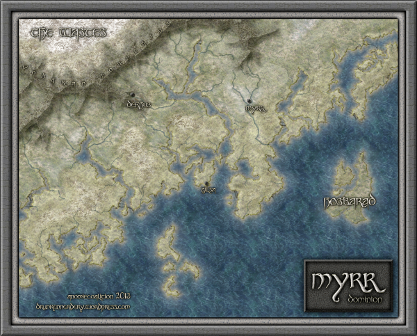
Myrr is a semi-arctic region largely inspired by Scandinavia, Iceland, and Alaska. I spent a great deal of time looking over maps of their fjords and river systems in the hope that I could create something similar and believable in my own map. After an hour or two tinkering around with the fractal line tool (adding a river here, indenting land mass there, etc), I finally had a landmass and set of islands I could be happy with.
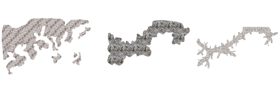
The next step was to create the mountain range. I first drew the main ridge of the mountain and all the little ridges that branch off of it with the smooth poly tool. This is what the looked like without effects on.
I gave it a rather long and dark wall shadow, a deep edge fade inner (with 75% inner opacity), and a large lighted bevel effect (so that the two sides of the bevel met in the center of the polygon). I then added a Mountain Hills sheet that encircled the range with a smaller edge fade inner and lighted bevel effect. Next, I added a Mountain Base sheet that encircled the Mountain Hills (also with a smaller edge fade inner and lighted bevel effect.) Because I wasn’t thoroughly happy with the colors that were coming out, I finalized it with a Mountain Cover sheet. This shows the details of the effects:
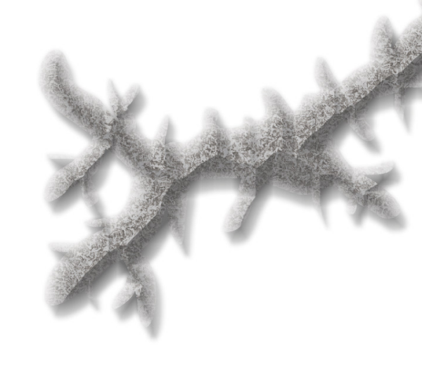
And this is the final mountain range:

As you can see, I also used the Mountain Base sheet to layout my hills. I further added a Hills Base sheet that encircle these hills and had a deep edge fade inner to give the illusion of height. From there I added some forests (very subtle), rivers, text, (about a dozen assorted sheets to get the ocean, landmass and desert looking right) and called it a day. All of the textures came from Herwin Wielink annual and CGtextures.com.
This map was a great deal of fun to make and I learned a new technique for mountains in the process. Of course, the best part is now crafting a history about this region to help fill in the gaps of my fiancée’s character’s back-story. Although I’m far from done, you can check what I have so far (along with a full resolution version of the map) at my blog.
9 Comments
Clercon | January 30, 2013 | CD3, Par lindstrom, Village
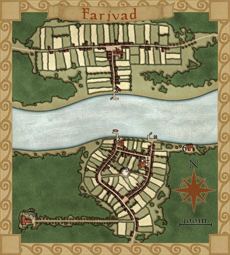
This is my latest map made in City Designer 3 (CD3), plus some effects added in Photoshop. It depicts the village Farjvad in the province Vadsbro and is part of the campaign/adventure I’m working on at the moment, even though I’ve mostly made maps so far.
Farjvad is situated about a day’s trip north east of the main town in the area, Vadsbro. Farjvad won’t actually be of importance for the adventure I’m writing, but it will still be a part of the campaign information. As you might have noticed I like to make maps, and making the adventure/campaign gives me some good reasons to do that. I also figured out that if I only have maps of the villages where the adventure takes place the players will rather quickly figure out what places are of importance and which ones are not. Also this will make the adventure feel much more unscripted if the players can go wherever they pleasein the area and the GM will have a nice map of the place.
So how did I go from a blank page to a finished map? What shall you think about while making a village map? First of all you have to decide where the village is situated, is it in a forest or a desert? The environment gives as well takes away possibilities for the map. In my case I know from the overland map of the province Vadsbro that Fjardinge is a village that is founded on two sides of a river, only connected via a ferry in the middle of a large forest.
I also decided that the south part of the village was the old one and that the north side is the new part where recent expansion of the village has taken place. Because that the village is situated in the middle of the forest there had to be some place for the villagers to go for protection if some kind of crises turned up. In this case I put a keep (nr 5 on the map) where the governor of the village used to live with his soldiers, maybe ten of them at a max. I could have gone with a palisade but in this case it didn’t feel right.
I also added a temple (nr 4), all places must have somewhere to go for religious need. The ruined temple (7) just outside the village was deserted when the new temple was done. What resides there today is up to the GM to decide.
Nowadays most travelers are using the northern road that leads from Vadsbro to the village Klyvholm. For this reason a newer part of Fjardinge has been built on the northern side. To make the sides differ a bit I decided to make the fields more square here, like they’ve been planned a bit. The big house at the square (nr 1) will also house the governor of the village (he decided to move here from his keep on the south side).
What I’ve actually have done here is making a story around the village and letting the story lead the way while mapping. I think I’ve stated this before but having a story in your head while mapping usually makes your maps more interesting, which means a better end result. It is also a lot more fun to map when you have a picture in your head of what the place looks like, it is like seeing your ideas come to life.
Originally posted on mappingworlds.wordpress.com
Comments Off on Farjvad
Clercon | January 22, 2013 | Annual, Campaign Cartographer, overland, Par lindstrom
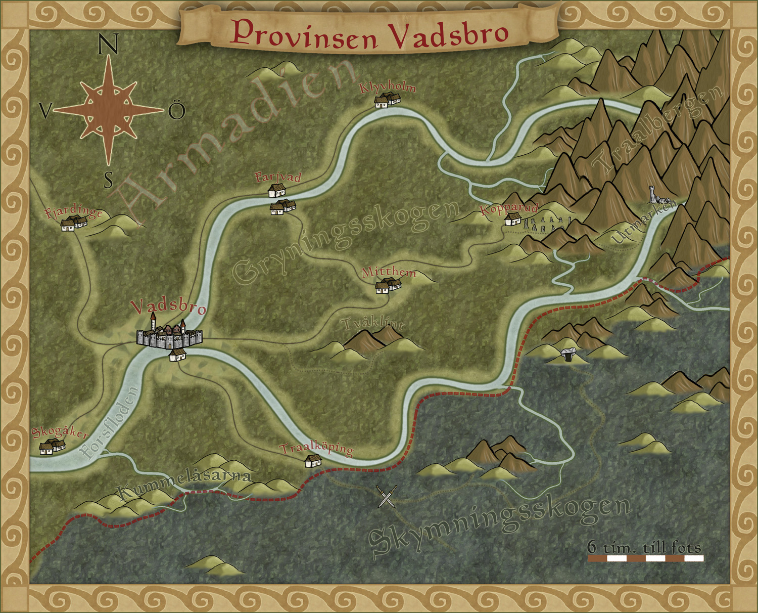
To get more ideas for maps to do I’ve decided to make a fantasy adventure. First of all I need a campaign map of the area where the actual adventure will take place, with that one in place it will be easier to plan the other maps I need to draw.
To make the map I decided to use the style I made for the December issue of the Annuals from Profantasy. The style was made for creating campaign maps for smaller areas, so it will fit very well for this map.
The adventure will take place in the country Armadien, close to a city called Vadsbro (Littlebridge in my Armadien map). Vadsbro is situated close to the Armadien border, next to the Traal infected Skymningsskogen (dusk forest) and the Traal mountains, so there will be a lot of forest in the map.
As soon as I started on the map I realized that I had to improvise a bit with the style. The main feature in the map, except for all the forest, is the river that split up in two rivers closer to the mountains. The rivers in the style aren’t really suited for depicting a main river in this scale, so I decide to use the ocean texture for the rivers. In this way the river will look more like the dominating natural feature in the area.
The river tool however comes in handy to show smaller rivers connecting into the main branches, but I had to change the colour of the rivers to blend in more with the main rivers. When I created the style, which is based on my Truscian map, I wanted the rivers in a darker colour and the ocean in a lighter one. That works very well if you do a more zoomed out map. But if you zoom in closer to an area for a map, and you suddenly want to use the ocean textures as rivers, the colour for the river tools don’t really blend in. So I decided to change them.
It is actually quite funny how a style you’ve created yourself, suddenly needs to be trimmed when you start working with it. But I think you can say that for all styles. At least I always trim the styles so they’ll fit into my way of working.
Now that the map is done it will be easier to decide what more maps I need to do. You can say that I’m making my adventure from the maps, the story I have so far will probably change a bit with every map I make. But that is the fun part of mapping, to weave a story around your maps instead of making maps from your story.
Originally posted on mappingworlds.wordpress.com
1 Comment
Simon Rogers | January 8, 2013 | user tutorials
[This map was created by forum user anomiecoalition.]
After a rather lengthy hiatus from the world of fantasy and roleplaying, I recently convinced a few friends to give it a try and set about constructing a world that would keep their interest. Along the way, I stumbled upon Campaign Cartographer 3 and was amazed at the maps that people were producing with it and the possibility that it provides to even the artistically challenged (like myself). After a short couple of week tinkering with the program and learning a great deal from the tutorials available I constructed Brightstone Keep.
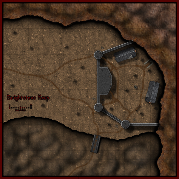
The map and its back story are loosely based on a free adventure provided by Wizards of the Coast. The keep protects a mining operation that has been overrun by a variety of nefarious creatures. The symbols utilized can be obtained from the CSUAC.
The first step in creating this map was to establish the basic layout. I depicted a mountain wall running from the top left to bottom right corner for which I used three separate sheets and shapes. Then I added cliff running left to right towards the bottom of the map on another sheet.
Adding the Mountain
I began by drawing a rough outline of the mountain wall and filled it with a dirt texture. I learned that it is a good idea to draw beyond the map border on these shapes to ensure that if I applied any edge-fade effects, they wouldn’t appear on the border side of the map. Using effects I then applied a slight blur and two black outer glow effects – one with strength of 0 above another with strength of 1. I then created two more shapes and sheets to go above this mountain wall and utilized different dirt textures. To these sheets, I applied a slight blur and an edge-fade-inner effect.
Adding the Cliff
Depicting the cliff was a bit simpler – here I just reused the dirt texture from the background but constructed a separate shape on a separate sheet and applied a similar setting as that use on the first mountain wall sheet (but with an inner glow). The final step was to add some hill overlay transparencies to add some character to the terrain. I applied these symbols on a separate sheet and varied the size/orientation to achieve the desired effect.
Adding the Keep
In constructing the walls of the keep, I created four sets of sheets and shapes. I began by drawing some solid gray lines (width of 6 – adjust to scale) to create the outer wall. I then applied a texture sheet effect (stone texture of your choosing, Intensity 1, size 15); on top of that a black outer glow (strength 1, blur 2); a wall shadow (length 15, opacity 65, blur 5); and finally a bevel (length 1.5, strength 35, and fade 1). I next wanted to create a walkway for that wall. I copied the image to a new sheet and reduced the width to 3. I then applied a texture sheet effect (with a different stone texture but same settings) and an inner black glow (strength 1, blur 2). I followed the same procedure to construct the towers/ramp and placed those shapes and sheets on top of the wall. (The ramp actually required that I draw in a black shadow on the right side to give it some dimensionality.)
The Road and the Rest
The last step was to draw in some roads and tracks. I laid down a road (added a texture, blur, and edge-fade-inner sheet effect) and then drew in the tracks according to the instructions provided in the Jon Roberts Special Issue of the Annual. From there it was just a matter of placing some vegetation, rocks, buildings, and text to complete my map.
I had a great time making this map and was amazed at how easy it was once I familiarized myself with the program (the video tutorials and assorted blog entries are invaluable.) I just hope my friends enjoy playing with this map as much as I enjoyed making it.
*I plan on posting more of my maps on my new blog
Comments Off on Brightstone Keep
ralf | January 2, 2013 | Annual, Cthulhu, handouts
The January issue of the Annual 2013, entitled “Investigation Props”, is now available. Be it your classic Cthulhu campaign set in 1920s and 30s, games set in even more recent times like Night’s Black Agents and Delta Green, or sci-fi settings like Ashen Stars – the January issue contains the tools to create handouts, charts and other props for any of these.
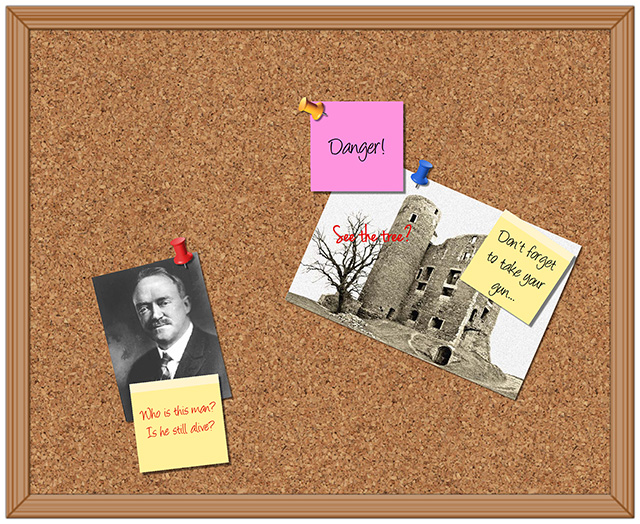
You can subscribe to the Annual 2013 here.
1 Comment
Simon Rogers | December 11, 2012 | Newsletter
The latest articles and news from ProFantasy for the festive season. 
News
Resources
[poll id=”4″]
5 Comments
