
You can now subscribe to the Cartographer’s Annual 2012 from the Profantasy web store. Check out previews for the first three issue on the Annual 2012 page.
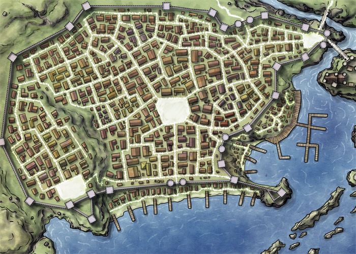
Preview of the March Issue: Jon Roberts’ Cities
You can now subscribe to the Cartographer’s Annual 2012 from the Profantasy web store. Check out previews for the first three issue on the Annual 2012 page.
Preview of the March Issue: Jon Roberts’ Cities
The final Annual issue for 2011 is here: A combined texture pack for Fractal Terrains 3 and Campaign Cartographer 3. Give your FT world a new look with the textured climate shader or draw climate maps of your regions in CC3.
Stay tuned for the Cartographer’s Annual 2012!
The December issue of the Annual 2011 is now available. It contains a companion style to April’s “1930s Floorplans”, reproducing the city maps of 1930s Baedeker travel guides. These make perfect handouts for period horror or pulp games.
Despite this being the December issue, the 2011 Annual is not quite done yet. As we released the June issue as a free download, we’ll be adding one more issue later this month.
Recently we added some new entries to our Profantasy user library. Check out these beautiful new additions:
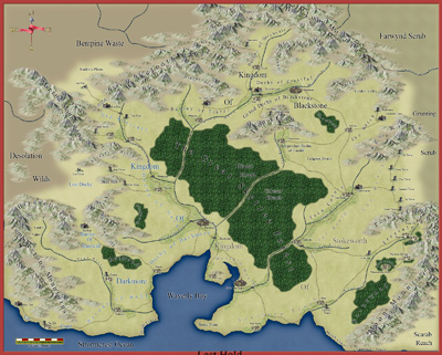
1. Richard Brunke’s Last Hold map created with the Jon Roberts Overland style from this year’s Annual.
 The November Annual issue was released on Tuesday, providing a detailed floorplan and street map of Moe’s Dive, a generic seedy bar to use in your adventures. It also contains a combined City Designer 3/Dungeon Designer 3 template for those close-up street battle maps.
We’ve just released the October Annual for subscribers to download: A beautiful map style inspired by classic fiction treasure maps. It allows users to easily create handouts for their game and set their players on the trail of that elusive treasure hoard.

September 2011: Military Operations
Due to after-GenCon demands and vacation times, we didn’t get around to posting about the September Annual when it was released. Here is sneak peek at the military operations type maps that can be created with its included style.
Inspired by the Geomorphic dungeons of Dave’s Mapper and the idea of vertical dungeon maps by Stonewerk on his blog, I created a set of geomorphic dungeon tiles for the August Annual complete with the style and tools to draw your own.
EDIT: The style was inspired by the images posted on the ProFantasy Community Forum, which I mistakenly thought came from Stonewerk’s Blog. The proper source is Dyson Logos’s blog “A Character for Every Game“. Sorry for the mistake and thanks for the great inspiration!
Here is my complete example map for Issue 56 of the Cartographer’s Annual (click image for a larger view):

Mark Needham created these beautiful castle floorplans for the Time Ref – Medieval History website:

He used the Jon Robert’s Dungeon style released as the June issue of the Cartographer’s Annual 2001. This style is freely available for download and showcases the beauty of Jon Roberts’ artwork, as well as the value of the content of our Annual subscription.
 Dioramas Pro is one of the more rarely used add-ons of CC3 – rather undeservedly though in my opinion. With a little care and patience it can create some spectacular setups for your gaming table.
This month’s Annual provides an example of what can be done with Dioramas, plus the tools and templates to create more paper models. So, break out those hobby knifes and glue bottles and start modeling…
Continue reading »
This map of Shadow World was created by Matt Hanson from the Cartographer’s Annual Vol 3..
I started creating a map of the continent of Jaiman on Shadow World® to include in an upcoming Player Guide. I wanted to create a comprehensive map that included all map related layers of data in all the official books: Places of Interest for players and GM’s, Essaence Flows, Climate, Navigator Obelisks, Roads, Cities & Towns, Kingdom borders in different time periods. However the base map was on the continent scale so I felt the “Fantasy Worlds” style from the April ’09 Annual would work best and give a nice simple and clean look.
I made a few changes to the standard Fantasy Worlds style. Given that the entire continent (45 to 70 degrees latitude) would be covered in forest I felt that the obvious borders in the standard forest (that uses a tree symbol fill) didn’t make much sense. Instead I changed the color of the default land fill to make it a darker and more saturated green. I also created two additional bitmap fills – one darker and greener, and one lighter and more yellow. I scattered a handful of polygons about using these fills to give further variation in the landmass, representing denser than average forest, and more sparse forest mixed with grassland.
Jaiman Map Copyright Matt Hanson 2009, based on Terry Amthor’s Shadow World setting , now published through Guild Companion Publications. Shadow World® is a registered trademark of Terry K. Amtho. This map will be available in final form in the upcoming Shadow World® Player’s Guides series.

