This month, we are offering five unlimited licenses which will entitle you to downloadable full versions of all our map-making software forever. The price is $1000, minus any amount you have spent on software in the ProFantasy store to date since CC3 was released.
Ralf will also create an example map based on something from your campaign world as part of the package.
If you are interested, please email simonwork@profantasy.com for more.
Comments Off on Unlimited Map-Making Software License
This time I thought it was time to make a tutorial on how you can make a convincing overland map. This will be more of an overview tutorial on how I think and plan when I make a map, so it won’t be very technical. This means that you can use this tutorial regardless what program you use when you map, even though I in the tutorial will use a map made in CC3 as a reference and example.
The first thing to take into account when you start an overland map is the landmass. How much of the map will be water and how much will be actual land? This is probably the most important step in your map because it will set the boundaries for what the end result will be. So already here I’m having a quite clear view of where I want to go with the map, shall the map be land based, island based or something in between.
Below you see my map “Sagorike”, that I’m using as an example in this tutorial, with only the landmass viewable. I’ve also written some things on the map that you can have in mind while drawing the coastline.
A good thing to do before starting on your landmass is to look at the real world (Google earth is great for this). If you want a lot of fjords, have a look at Norway, Island based, look at area outside Stockholm for example, and so on. It is always good to find inspiration in the real world. It will make your map look more believable, and believable maps tend to look good.
However when I make maps of worlds the most important thing for me is that they look good and in some part convincing. It doesn’t matter if the world doesn’t work geologically or physically, as long as it looks convincing. To make it look convincing you have to get the things right that the majority of people can spot, like rivers, they will NEVER split downwards, lakes, there is always only ONE outflow, or deserts, make sure that you place them in a way that it looks probable that no rain will get there, and so on. If those small details are correct it is more likely that the viewer will believe in the whole map, regardless if everything in it is possible according to our physical laws or not.
That is all for now, in the next post we will start by placing the mountains in the map.
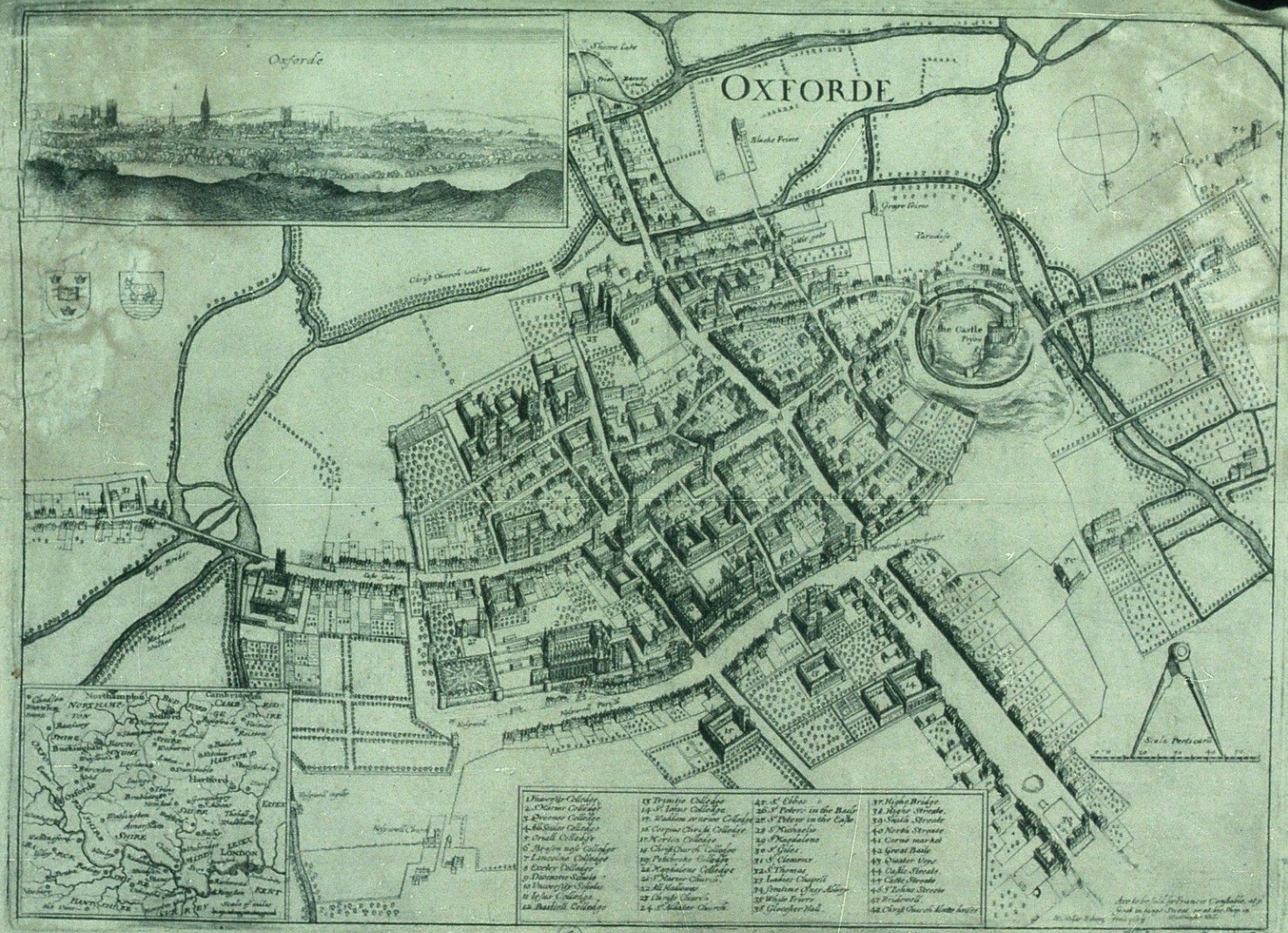
Up to now we’ve mostly been working inside the city walls, where space is short and buildings necessarily packed
Historic map of Oxford in 1643
closely together. We’re now going to turn to the area outside the walls. In this installment, we’re going to turn back to some theory.
First we need to talk about why businesses decide to set up outside the walls of the city. After all, they are forgoing the protection that walls bring, so there must be some good reasons for it. It turns out the reasons are pretty simple:
Avoiding authority: This is monetary, avoiding taxes, but also includes regulation, attention of the town watch, even to avoiding the prying eyes of neighbors. The city’s authority ends with the city walls, and some people find their business flourishes where there is less oversight.
Accessing markets: Gates into the city are notorious choke points for people entering the city. The gates typically only open at certain times, guards ask questions, and just the physical size of the gate all conspire to leave large numbers of people waiting outside to get in. And where there are large numbers of people waiting or stranded, there is money to be made selling goods and services to them.
Space: In many cities, space is at a premium. So businesses that require lots of space such as cattle markets, or that need space from neighbors, such as tanners, will often set up outside the city walls.
Over the last five years the RPC (Role Play Convention) has grown to be Germany largest roleplaying convention. Spiel in Essen is still much bigger, but where it is mostly a boardgaming affair the RPC is about evenly split between computer gaming, LARP and pen and paper rpgs. As this is much closer to our software’s audience, we decided it was time that we gave the RPC a try. I had visited the show for the past three years and knew roughly what to expect, but you never really know how a show turns out until you try it.
I was a bit upset, when after registering in January it took the organizers until April to get back to us with confirmation and details – and the Profantasy booth suddenly sat smack in the middle of the computer gaming area. But from there communication with and help from the organizers was excellent. They were very responsive to my questions and concerns and we got moved into the proper pen&paper area very quickly.
Cologne is close enough to my hometown (about 50 mins drive) that I didn’t need to get accommodation near the show. In contrast to Essen, exhibitor parking and set access to the halls is very convenient, and I was able to do the setup in a relaxed manner on Friday night, without driving through heavy traffic and worrying about closing times. All equipment we had ordered was on site, in good condition, and we were able to create a nice and professional looking booth.
The show had changed halls from last year and while this provided ample space, it had one drawback: Computer gaming was in the same hall as the other exhibitors, and those booths are VERY loud. Luckily we were far enough away so that it didn’t bother us too much, I heard many visitors complain about the noise on Saturday. It seemed like they toned it down a bit on Sunday. Apart from that the atmosphere was more relaxed than in Essen. Everybody was very friendly and one of the highlights of the show are the many costumed people (exhibitors and visitors).
Due to significantly less visitors (organizers claim 30,000 and 120,000 visitors respectively) and large aisles there were never any jams (as there are sometimes in Essen). But questions, sales and demos did keep me busy throughout both days, so that I was glad about the occasional breather when Gordon and Michael (my helpers on Saturday and Sunday respectively) took care of the booth. The only boring stretch was the last two hours on Saturday – the halls were basically dead after 6pm and the show went on to 8pm, unnecessarily in my opinion.
When I started doing shows for Profantasy i tt used to be that current customers used these occasions to buy the new things we had on offer or stock up with add-ons they hadn’t pruchased yet. These types of sales are basically gone – with few exceptions people buy these things online. The Internet and credit cards (or Paypal) have seen to that. Most sales nowadays are to new customers (which is a good thing) who have either never seen Campaign Cartographer before or who have heard about it and want to take a look at it before buying. Of our sales at the show 90% included a CC3 – meaning they were to new customers, or people getting back into it after CC2.
Responses were good from both old users and the ones who saw it for the first time. I had one guy just walk up and thank me enthusiastically for our software – he was using CC3, Fractal Terrains 3 and Cosmographer 3 for great effect in his Sci-Fi campaign he said. Another customer complained about how hard it had been to use CC2 when he tried it years back, but was happy to purchase CC3 after I showed him the improvements in the user interface.
I unexpectedly met Herwin Wielink (fantasy-maps.com) at the show (he drove over from Amsterdam) and we had a nice talk about mapping and fantasy cartography.
The “Wall of Maps” continues to be the biggest pull for customers walking by the booth – we got many awed comments – but the little dungeon diorama I had on the table also got quite a bit of attention. Many people inquired about how it was done, what materials I used, and so on. As most of the interested people were new to CC3, demoing was mostly limited to CC3, CD3 and DD3, with the occasional bit of Cosmographer and Fractal Terrains thrown in.
Taking the booth down was quick and painless on Saturday evening. Michael was there to help, and we were done and away in 30 minutes. Doing a 2-day show is also a lot less stressful than a 4-day one. The 1-hour drive to and fro is a bit annoying of course, but at least I get to be home each night. Of course I was tired after the show, but overall a lot less exhausted than after Spiel or GenCon. As it looks, I’d be happy to do the RPC next year again.
[Editor’s note: Forum member Mateus Buffone posts about his excellent Panorica map]
Some days ago Simon Rogers asked me if he could use my map as “The Map of The Month”. When I read it, I could not believe it. I started the hobby last year and I am still learning the tricks of the trade, so it’s an honor to have a map that I made posted.
This map is named Continent of Panorica and I did the first version of it in less than an hour for a RPG game that I would begin on the next day. The first thing that I neded was a style that would fit well in a continet map and that have a “fantasy” feel, as what I wanted was a fast and “cliché” map for a fast and “cliché” world. So I choosed the CA51 Jon Roberts Overland Style that is part of the 2011 Annual.
I generated landmasses in Fractal Terrians 3 until I saw one that would fit my needs. Than I exported it to CC3 and fractalized a little more. After that I used the Land Default tool from the style and drew the islands, then used Fractalize on them to achieve a nmore natural feel. The next step was to place the mountains ranges. I was not concerned very much with realistic geology but I did not want to explain all my world with “magic!”, so I placed them first near the coast where I thought others continents would exist if I some day did the whole world. Then I placed the central chains as I needed a desert for my game. For the first version I only needed the central region so I placed some of the major rivers of the continent and dotted some settlements near the desert to form a pseudo-Arabian/tuareg region and called it a day.
But at that point I was in love with the project and wanted to transform it in my fixed fantasy map for the kind of game that I was running (a GURPS Dungeon Fantasy campaign). So I needed other regions and more details. So I begin to really think about the whole image: what cultures lived there, their society and political organizations. I decided to made the banners of the diferent kingdoms and others political organizations. For it I used the CA15 “Heraldry” from Annual 2008 and exported then as FCW entities to my continent map. I used some symbols found on the Map & Catalog Library in the ProFantasy home page. First I had a lot of dificults to implement the shields because messing with sheets is not very easy, but when you learned what to put where they are a big time saver! For the desert, florest, farmland and scrubland terrain to work on this map I had to rescale then for just 50% of their original size (this tip was gave to me by Simon himself).
[To rescale a bitmap fill style:
1. Click on the Fill Styles Indicator, the Bitmap Fills tab, and find the texture on the Fill Style Name pulldown.
2. Reduce the Scale Width and Height (maybe to 50%) and OK.
3. Try again until it looks right.]
Another point of interest was the underwater setlements (Forte do Sino inside Terras Alagadas and the whole southeast region). I spend a big time with then and in the final I only neded of an Transparency effect. And I think that this is one of the most import aspects of CC3. When you find good effects and know how to create and manage sheets for each of your maps you can achieve very good results.
I hope that you like my map and if have any suggestion talk with me on the community.
He says of this ship, created with Cosmographer 3:
Like many forum members, I’ve been drawing maps (both fantasy and sci-fi since I was a kid of 9 or 10 years old). I’ve had CC3 since February-ish of last year, but took a really long break from it while I was looking for work. I think that my tenacity and OCD makes up for my lack of initial planning and can’t keep things well enough alone 🙂 I often only have a faint image of how a landscape, ship or city is going to end up and each often goes through several revisions before I’m satisfied with the result. I find it’s a very organic (and sometimes frustrating) process: the land shapes the features shapes the cities and roads shapes the land…
The ship in this thread grew from the idea of an engine and a bridge connected by a spine, different modules could be plugged into the spine depending on the mission requirements (living spaces, labs, hanger bays, cargo, etc.) BUT… when I started drawing the modules I drew the rooms to small and nothing fit in the “slots”, so I took what I liked (the bridge) and then built the captian’s cabin, first starting with the furniture and then building the walls. Once that was done it was time to think about the “why” of the ship, it made sense to me that the captain and first officer would have cabins on different sides of the ship (in case of attack one hit wouldn’t take them both out). So I coppied the bulkheads of the captain’s room and turned it into the XO’s and NCO’s quarters (as they would have less room than the CO)! the rest of the ship just sort of grew from there.
Well, that was a bit a tangent but gives you an idea of how I Cartograph (is that a word?)! To summarize, I’m playing, learning and expermenting all the time to share what I see in my head with others.
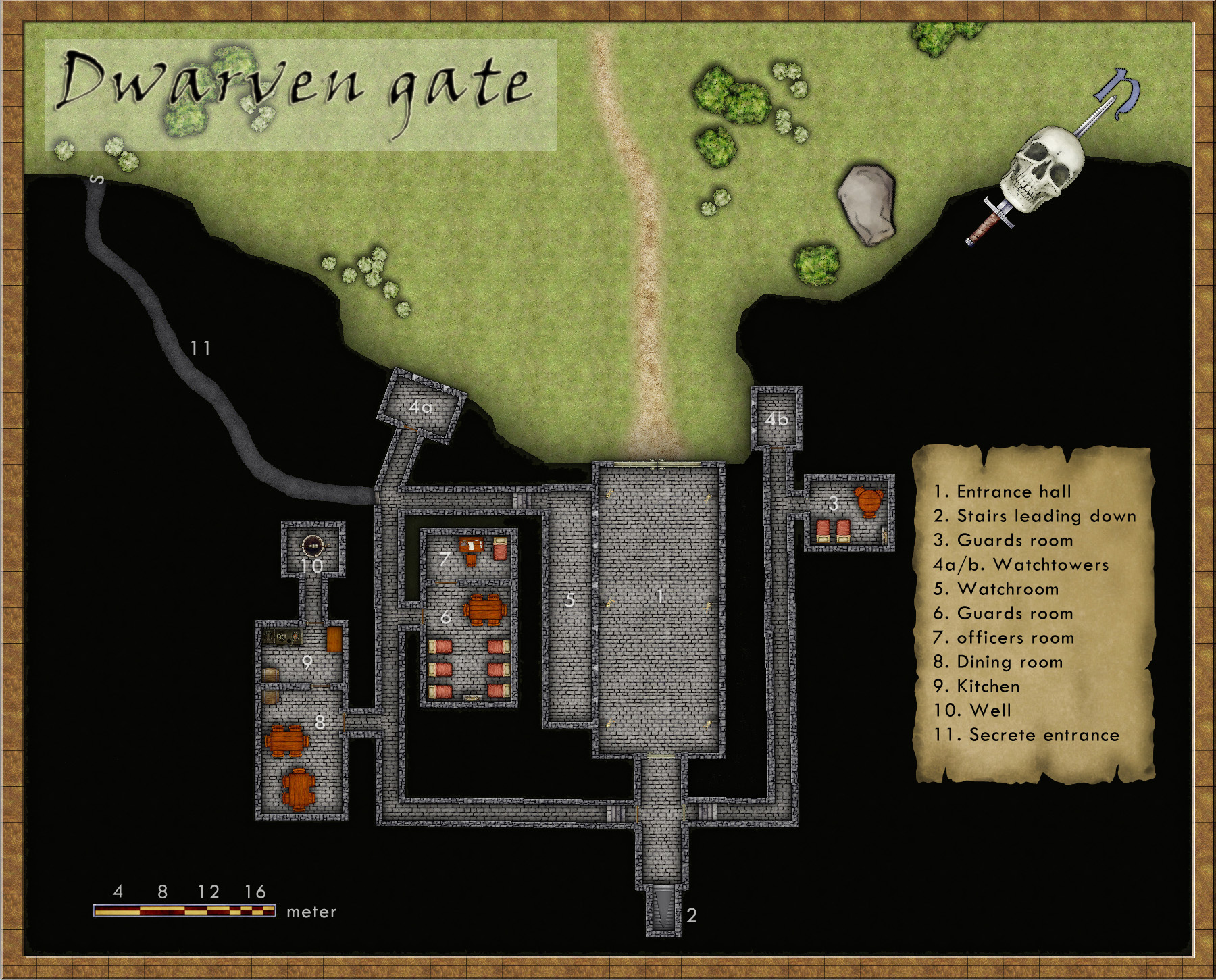
I’ve always been very fond of Dwarves and their mines as a great location for an adventure. I guess you can blame this on Tolkien and his description of Moria. I still remember how excited I was when I saw the Lord of the rings on TV for the first time (now we’re talking about the old film, not the new ones) and they entered the old mines full of orcs.
This map however is only of the entrance to a Dwarven kingdom. It is made in the Dungeon Designer 3 add on for Campaign Cartographer 3. The style used is from the 2011 annual, Jon Roberts Dungeon. This particular style is actually free for anyone to download.
When I map some kind of fortification I always try to picture how an attack on the area would be done. How could I defend the area in the best way? Whoever that want to get past the fort has to pass through the entrance hall (1) on the map. So I wanted the entrance hall to be well guarded, I accomplished this through the watchroom (5) next to it. From there the guards can watch who enters and also shoot at them. The inner iron door will hopefully prohibit any hostile intruders from getting any further in.
The two towers facing the outside (4a-b) are also good spotting areas from where you can see who’s approaching as well who’s standing in front of the gates. I try to continue thinking in this way while mapping, other important aspects are where will the guards sleep, eat or relax? Remember this is a place where the guards probably spend a week at a time before they are relived.
In the end I also added the secrete passage (11). This passage shouldn’t really be there because it is a huge security risk. The reason I put it there was that if some adventurers need to sneak in past the guards they need a way to do it. So the passage was added to make the map more fun to use in an adventure.
This was the first map I made in Dungeon Designer 3. The program however I feel is the most complicated one from Profantasy, mainly because there are so many different things you can add and have to take into account. It took me a long time to realize that I in this map actually by mistake used the wrong beds and tables (they are from another style then the one I intended to use). So it was very good to have the pdf from the annual style to use as a guide while exploring the program. This however doesn’t mean that this is a bad program in any way, probably the contrary. But it crave from you as a user that you take the time to learn it.
The kind people over at the Vintyri Project have released their textures in CC3 format. Their symbols libaries are to follow.
The March edition of the Cartographer’s Annual is out. Download an A2 PDF of Ralf’s amazing example map.
See a preview of the forthcoming 3D dungeon style for the Annual
Remy Monsen is now laying out the latest Tome of Ultimate Mapping. We hope it will be ready in April. Everyone who bought the Tome after the release of CC3 will get a free update. He wrote about the Tome last month.
First off, I apologize for the long lag between part 5 and 6 of this series: it was not my intention, but a series of life events conspired to take me away from mapping. But I’m back. Thanks to everyone for the kind words of support along the way.


")