Recently we added some new entries to our Profantasy user library. Check out these beautiful new additions:
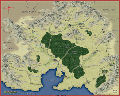
1. Richard Brunke’s Last Hold map created with the Jon Roberts Overland style from this year’s Annual.
Recently we added some new entries to our Profantasy user library. Check out these beautiful new additions:
1. Richard Brunke’s Last Hold map created with the Jon Roberts Overland style from this year’s Annual.
 The November Annual issue was released on Tuesday, providing a detailed floorplan and street map of Moe’s Dive, a generic seedy bar to use in your adventures. It also contains a combined City Designer 3/Dungeon Designer 3 template for those close-up street battle maps.
by Pär Lindström
The reason for making this map was that I wanted to try out some water colour/oil paint effects in Photoshop on a CD3 map, as a way to give the map a more hand drawn feeling. When I make a city map I find it much easier if I have a story to tell in the map. If you have a reason for why things turn out the way it does it will feel much more convincing in the end. This is the drawing pre-Photoshop – click for a high-res version.

In this specific case I decided to draw a map of the town Littlebridge. A small town two days travel into the forest in the country Armadien in my Etrakien fantasy world. The town is situated not too far away from an area called the “Traal lands”. Traals are Troll like creatures that lack in technology what they gain in physical power. When the Traals don’t trade with the people in Littlebridge they come to plunder. This is the version post-Photoshop. Click for a high-resolution version.

So the city had to be well protected and with some of the food production inside the heavy stone walls. I also wanted the city to have some docks to show that it is a trading centre. Then of course as in all towns you will have more or less buildings just outside the gates. I also decided to put a large house outside each gate as a kind of inn for travellers that arrive after the gates to the city has closed for the day.
The map is completely done in CD3 (bitmap A) when it comes to terrain and houses. The labelling is done in Photoshop (mostly because I’m too lazy to learn how to do it in CD3) and I’ve also added some oil paint effects in Photoshop on the end result to achieve the purpose of the map.
In this, the fourth part of our series on mapping cities, we will spend time setting up a district using Campaign Cartographer 3 (CC3). We will be using the City Designer 3 (CD3) add-on because it makes the job of mapping cities much easier. But pretty much everything we do in this tutorial can be accomplished with the based program – it’s just more work, and your style and building options are fewer.
When we get to the step of mapping individual buildings, you’ll definitely want to have a copy of CD3 because the end result is so much better.
We are going to rough out the entertainment district of our map (the red district just above center):

My original city map was created in an old version of CC3, so we’re going to copy the district and put it in a new map. Continue reading »
In the previous two installments of this series, we determined where a city is likely to arise, and did some basic planning for a city (read Mapping Cities Part One here and Part Two here). In this installment we will plan out a district in more detail.
There are four things to keep in mind when thinking about the structure of the district:
Affecting all four of these mapping factors is the question of age: As districts age, they change and deviate from plans, space is filled in, walls are torn down, roads and squares infill. A fundamental right for city dwellers was the right to own land, and new cities are laid out in standard-sized burgage plots. The size of these plots vary from city to city, but are uniform within the city: Typically 10-20 meters wide facing the street, and 50-100 meters deep when first laid out.
The plots are large enough for outbuildings, keeping animals and small gardens. But as space pressure increases, the plots are subdivided and filled in. Usually the divisions stay within single plots, but the example below shows two plots that were split up together.

Over time city plots are filled and subdivided
As you lay out plots, you need to make sure that every building has access of some sort to the road, even if it is through an alley. In the example I give above, the grey areas are alleys. As you have ideas for points of interest, add them now or make notes for later.
I occasionally cheat and put in plot divisions that are not road-accessible. I just know that they will need a passageway through another building (maybe an arched gateway) or they need to be abandoned buildings that I can use later in my campaign.
Next time, I will show you how to apply these rules in Campaign Cartographer, using an entertainment district of my city.
The City Mapping Series
Part 1: Location, Location, Location
Part 2: Urban Planning
Part 3: Laying out Districts
Part 4: Districts in CC3
Part 5: Sizing Buildings
Part 6: Filling Blocks in CC3
Part 7: Houses Galore!
Part 8: Outside the Gates
The May issue of the Cartographer’s Annual 2011 has been available since Sunday. It contains a new style to draw modern road atlas maps, both on a regional or local level:

Modern City Street Map
Cities are one of the greatest environments for RPG adventuring. In a tight space, players can reasonably encounter every type of roleplaying challenge and meet each with a dizzying array of strategies and tactics. Cities can also be a gamemaster’s (GM) nightmare. It’s difficult to know where players will go next, detailed preparation is almost impossible, and everything should be available. To be successful, GMs need overall planning and a good city map. This series will get you started on the map and support your planning.
This is the first of a short series of articles on mapping cities for fantasy roleplaying games. I’ll show you the main considerations as you place, design, detail, and then play in the city. When we’re done, you’ll be able to draw out a reasonable city with confidence and present your players with an experience they won’t forget. I use ProFantasy’s Campaign Cartographer as my main mapping tool, and all of the maps are drawn with it. There is no post-processing on any of the maps.
I recommend that as you build your own city, that you keep a notepad at your elbow to record your thoughts and designs. Mapping is a creative process, and you will find that you generate many ideas for future adventures as you create your maps. Write the ideas down, and transfer as many of them to the map itself as you can. That way you can find them when you need them. So if you’ve just mapped a narrow pass that would be perfect for an ambush, add that encounter idea as a “GM-only” hidden note. If you don’t write them down in the moment, it’s often tough to remember or recreate the ideas later. And it’s great to be preparing for a gaming session and pull up the notes as a way through creative blocks. You will find that in city building, these notes are critical to make the city come alive later.
Cities in the middle ages were rare. Fewer than a dozen true metropolises existed before the modern era. That is because a city needs the following things to grow and flourish:
The first task for anyone mapping a city is to find a suitable site for the city. On the map below, I’ve mapped the most likely places for a city to grow:
 If you’ve read our previous article, Mapping Cities 1, welcome back. If you just joined us, look at that first article, or just follow along from here. So far, we’ve found a place for the city, determined its size and laid out the general geography and boundaries.
Next, we’re going to add details to work up to an overview map of the city.
First, we need to place the major features of the city: Points of interest, major districts, entry points, roads, and other trade points. I generally cycle through these one by one, and continue going through the list until I am out of ideas. I’ll place these items on the map as labels or symbols to guide my further development. Here are some design considerations:
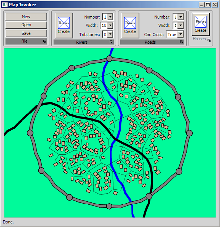
L Lee Saunders is working on a random city generator for CC3. Lee has worked with ProFantasy for many years, producing features such as the fractal path and text around a curve. He has an excellent development blog for people who want to create CC3 add-ons, which he will mirror here.
The Random City Generator will be included in a future version of Campaign Cartographer or City Designer, or be available as a separate product. He’s gone beyond proof of concept – here is a screen shot. It already does basic CC3 import using the House command, and we’ll be reporting on its progress regularly.