ralf | September 1, 2015 | Annual, Dracula Dossier, Floorplan, Pelgrane
 Seeing the recent pre-order release of Pelgrane Press’ Dracula Dossier, we are thrilled to offer the Dracula Dossier mapping style as this month’s Annual issue. This very set of tools was used to create the floorplan maps in Pelgrane’s massive improvisational campaign. Now you can use it for your own modern-action-horror locations!
The September issue is available both for CC3 and CC3+. You can download both setups from your registration page on the Subscriptions tab. If you haven’t subscribed to the Annual 2015 yet, you can do so here.
Comments Off on Cartographer’s Annual: September Issue
ralf | August 3, 2015 | Annual, overland maps, Par lindstrom
 We have a wonderful new overland style by Pär Lindström for our subscribers in the August issue. The style is supremely suited for local area maps and therefore works nicely to illustrate stories or small-scale rpg adventures.
The August issue is available both for CC3 and CC3+. You can download both setups from your registration page on the Subscriptions tab. If you haven’t subscribed to the Annual 2015 yet, you can do so here.
1 Comment
ralf | July 1, 2015 | Annual, city, panorama, Vandel
 It’s summer (well, at least here in the northern hemisphere), it’s July and here’s the seventh issue of this year’s Cartographer’s Annual. Draw panoramic views of your cities in the style of 16th-century publishers Braun & Hogenberg, with TJ Vandel’s new style “City Panoramas“. Almost 400 new symbols allow you to construct landscapes and and settlements in a bird’s eye view with speed and ease.
The July issue is available both for CC3 and CC3+. You can download both setups from your registration page on the Subscriptions tab.
If you haven’t subscribed to the Annual 2015 yet, you can do so here.
1 Comment
ralf | June 17, 2015 | ashen stars, Cosmographer 3, scifi, starship
 Dive into the depths of space with the June Annual and the Mandible-class starship. Inspired by the Ashen Stars RPG by Pelgrane press, this set of four deckplans shows a complete starship in high detail. An extensive sheets & effects guide discusses the different sheets and effects used in the drawing, so you can apply the principles to your own designs.
If you haven’t subscribed to the Annual 2015 yet, you can do so here.
Comments Off on Cartographer’s Annual: June Issue
ralf | May 21, 2015 | Dracula Dossier, Floorplans, GUMSHOE, Pelgrane
 This is another bit of synergy between the sister companies Profantasy Software and Pelgrane Press. Pelgrane’s Kickstarter project for the “Dracula Dossier” was a huge success, and for the many locations detailed in the campaign, they needed a unified map-style that different cartographers could use.
Realizing that the same would be useful to ProFantasy’s user base, we set about creating a floorplan style which could also be published as an issue of the Cartographer’s Annual. The style had to adhere to a few guidelines from the Dracula Dossier art direction: A clear and straightforward look, that fits the game’s modern setting, legibility at a variety of different scales and in various environments (books, pdfs, web), and of course matching the book’s layout and color design.
You can see the first map in the new “Dracula Dossier” style on the right (click the image to see a larger scale version). It details the underground remains of “Carfax Abbey”, Dracula’s estate during his stay in England. You can read a preview of the site’s description here.
The Dracula Dossier annual style will be available later this year, closer to the release of this exciting campaign for Night’s Black Agents.
Comments Off on Vampires and Spies: Dracula Dossier Maps
ralf | May 1, 2015 | Annual, novel, overland
 The May Annual issue goes back to the roots of fantasy mapping both in terms of CC3 and the maps we’ll create. Many of us fantasy mappers have originally been inspired by the maps we found in fantasy novels, from the Lord of the Rings to the Wheel of Time, A Song of Ice and Fire and so many others.
The Classic Fantasy style gives you the opportunity to draw maps those yourself, on a beautiful parchment background, so they will also make great handouts for your players. As always you can download the style from your registration page.
If you haven’t subscribed to the Annual 2015 yet, you can do so here.
Comments Off on Cartographer’s Annual: May Issue
ralf | April 14, 2015 | community, Maps of the Month, user maps
It’s time for another look at last month’s maps on the community forum. Let’s see what the CC3 users have come up!
Look at these beautiful floorplans created with Symbol Set 4 (Mike Schley Dungeons) by SlaveOne. Check out the forum thread for even more of them. I’m especially in love with the “Lucky Hobitz Futs” tavern.


Suntzu is using CC3+ to draw maps of Harn, look at his beautiful versions of the whole of Harn and the Melderyn isle.


Continue reading »
Comments Off on User Maps: March
ralf | April 1, 2015 | black and white, Par lindstrom, town, Village
 The Annual’s April issue is here on time (and totally without a prank), with another beautiful black and white drawing style by Pär Lindström. This time he gives us the tools and artwork to draw town and village maps in a beautiful, but still easy style. As always you can download the “Black and White Towns” style from your registration page.
If you haven’t subscribed to the Annual 2015 yet, you can do so here.
Comments Off on Cartographer’s Annual: April Issue
ralf | March 2, 2015 | Annual, McAlea, Science Fiction, scifi
 It’s time for some futuristic maps with the March Annual issue that has just been released. Steph McAlea created a set of symbols and textures that makes drawing planetary star ports a snap. Grab the style pack “SciFi Downports” from your registration page.
If you haven’t subscribed to the Annual 2015 yet, you can do so here.
Comments Off on Cartographer’s Annual: March issue
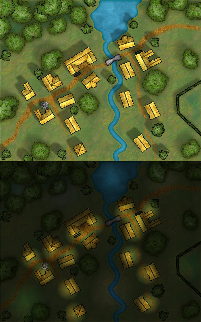
ralf | February 2, 2015 | Annual, Lighting, Tutorial
 It’s easy to overlook the small things, with the big release of CC3+ last week, but we should not forget it’s a new month and a new Annual issue is available: The Tutorial Pack – Day and Night. If you are a subscriber, you can download it from your registration page.
This tutorial takes an in-depth look at creating differently lighted environments, for example if you want to show a combat encounter area in both daytime and nighttime conditions.
If you haven’t subscribed to the Annual 2015 yet, you can do so here.
Note on CC3+: For now this Annual issue is done for CC3, as the CD3 and DD3 add-ons are not updated for use in CC3+ yet. Starting next month, we’ll make the Annual issues available in both CC3 and CC3+ versions.
Comments Off on Cartographer’s Annual 2015: February Issue
 Seeing the recent pre-order release of Pelgrane Press’ Dracula Dossier, we are thrilled to offer the Dracula Dossier mapping style as this month’s Annual issue. This very set of tools was used to create the floorplan maps in Pelgrane’s massive improvisational campaign. Now you can use it for your own modern-action-horror locations!