Simon Rogers | January 30, 2013 | effects, overland, Tutorial
[Ed’s Note: Let us know if you like this style, and with Flavio’s permission, we’ll create an Annual from it]
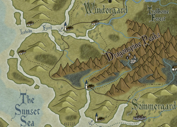
My fiancée recently asked me if it would be OK to make a Viking character for my Al-Qadim campaign. I thought about the role playing possibilities for a moment: Viking gets lost at sea en route to pillage and plunder; Viking gets shipwrecked in hostile desert environment; Viking PC makes for a very interest game indeed. I then thought about where such a Viking would come from in my world and set about creating a map of his home.
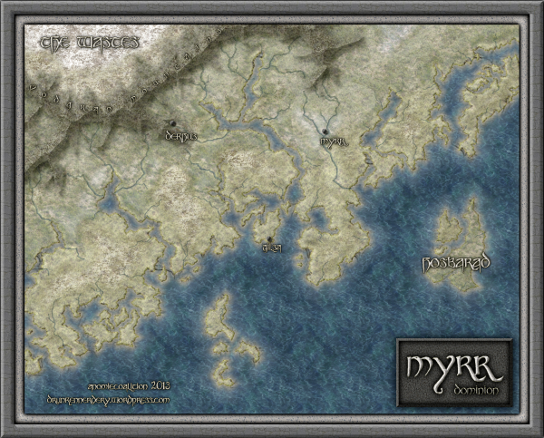
Myrr is a semi-arctic region largely inspired by Scandinavia, Iceland, and Alaska. I spent a great deal of time looking over maps of their fjords and river systems in the hope that I could create something similar and believable in my own map. After an hour or two tinkering around with the fractal line tool (adding a river here, indenting land mass there, etc), I finally had a landmass and set of islands I could be happy with.
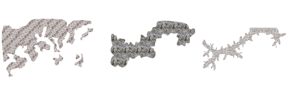
The next step was to create the mountain range. I first drew the main ridge of the mountain and all the little ridges that branch off of it with the smooth poly tool. This is what the looked like without effects on.
I gave it a rather long and dark wall shadow, a deep edge fade inner (with 75% inner opacity), and a large lighted bevel effect (so that the two sides of the bevel met in the center of the polygon). I then added a Mountain Hills sheet that encircled the range with a smaller edge fade inner and lighted bevel effect. Next, I added a Mountain Base sheet that encircled the Mountain Hills (also with a smaller edge fade inner and lighted bevel effect.) Because I wasn’t thoroughly happy with the colors that were coming out, I finalized it with a Mountain Cover sheet. This shows the details of the effects:
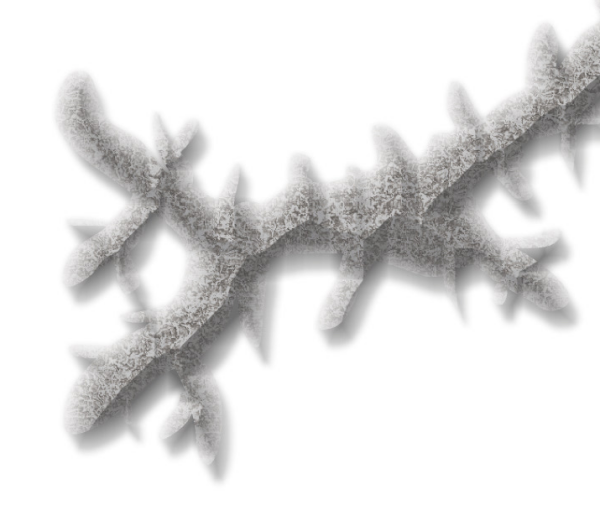
And this is the final mountain range:

As you can see, I also used the Mountain Base sheet to layout my hills. I further added a Hills Base sheet that encircle these hills and had a deep edge fade inner to give the illusion of height. From there I added some forests (very subtle), rivers, text, (about a dozen assorted sheets to get the ocean, landmass and desert looking right) and called it a day. All of the textures came from Herwin Wielink annual and CGtextures.com.
This map was a great deal of fun to make and I learned a new technique for mountains in the process. Of course, the best part is now crafting a history about this region to help fill in the gaps of my fiancée’s character’s back-story. Although I’m far from done, you can check what I have so far (along with a full resolution version of the map) at my blog.
9 Comments
Clercon | January 22, 2013 | Annual, Campaign Cartographer, overland, Par lindstrom
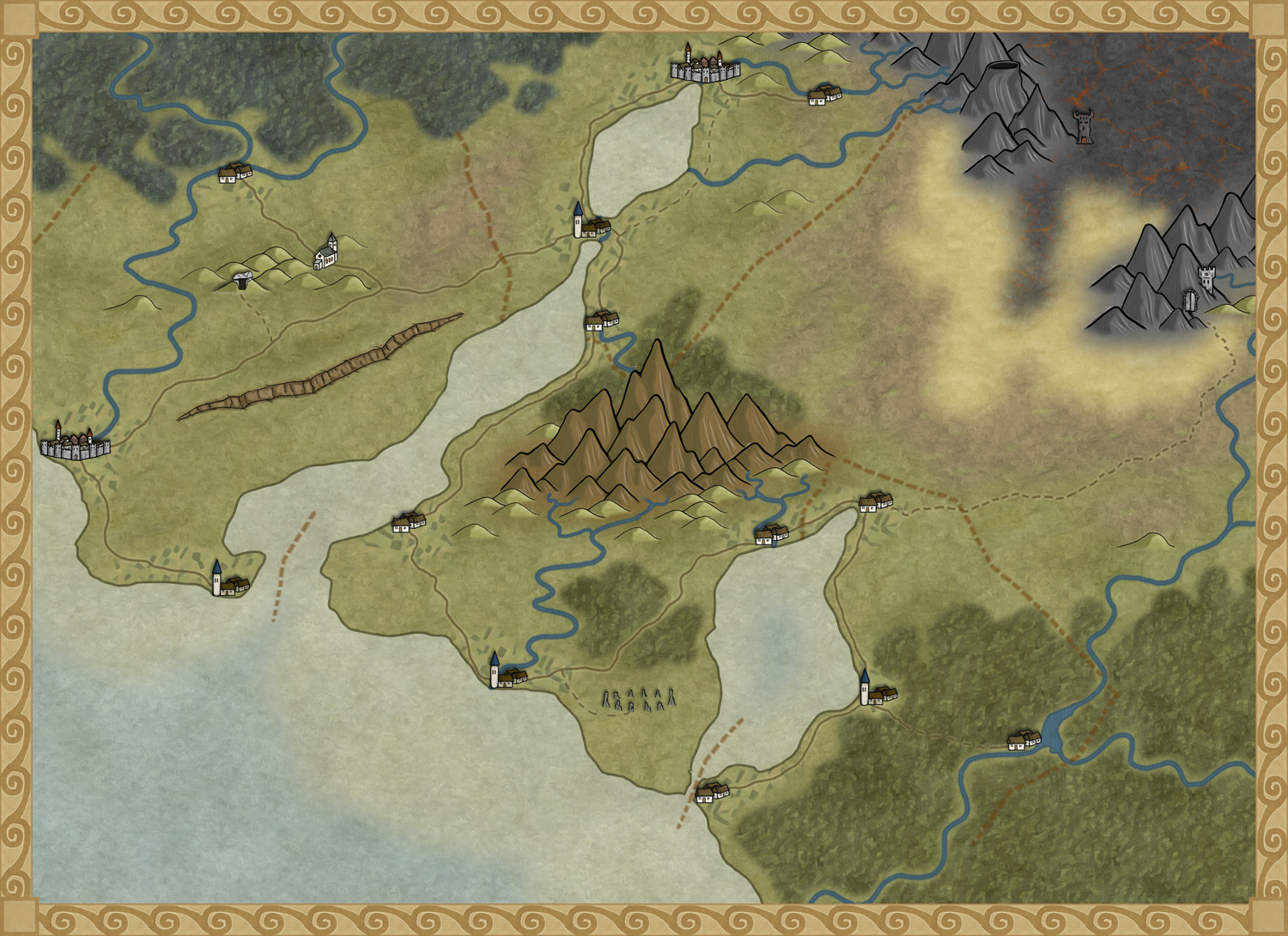
To get more ideas for maps to do I’ve decided to make a fantasy adventure. First of all I need a campaign map of the area where the actual adventure will take place, with that one in place it will be easier to plan the other maps I need to draw.
To make the map I decided to use the style I made for the December issue of the Annuals from Profantasy. The style was made for creating campaign maps for smaller areas, so it will fit very well for this map.
The adventure will take place in the country Armadien, close to a city called Vadsbro (Littlebridge in my Armadien map). Vadsbro is situated close to the Armadien border, next to the Traal infected Skymningsskogen (dusk forest) and the Traal mountains, so there will be a lot of forest in the map.
As soon as I started on the map I realized that I had to improvise a bit with the style. The main feature in the map, except for all the forest, is the river that split up in two rivers closer to the mountains. The rivers in the style aren’t really suited for depicting a main river in this scale, so I decide to use the ocean texture for the rivers. In this way the river will look more like the dominating natural feature in the area.
The river tool however comes in handy to show smaller rivers connecting into the main branches, but I had to change the colour of the rivers to blend in more with the main rivers. When I created the style, which is based on my Truscian map, I wanted the rivers in a darker colour and the ocean in a lighter one. That works very well if you do a more zoomed out map. But if you zoom in closer to an area for a map, and you suddenly want to use the ocean textures as rivers, the colour for the river tools don’t really blend in. So I decided to change them.
It is actually quite funny how a style you’ve created yourself, suddenly needs to be trimmed when you start working with it. But I think you can say that for all styles. At least I always trim the styles so they’ll fit into my way of working.
Now that the map is done it will be easier to decide what more maps I need to do. You can say that I’m making my adventure from the maps, the story I have so far will probably change a bit with every map I make. But that is the fun part of mapping, to weave a story around your maps instead of making maps from your story.
Originally posted on mappingworlds.wordpress.com
1 Comment
ralf | December 2, 2012 | Annual, overland, Par lindstrom
We’ve just released the final issue of the Annual 2012, and a fine one it is! Pär Lindström – creator of our popular Fantasy Worlds style – has created a beautiful mapping style for regional maps.
We’ll be releasing information on next year’s Annual soon!
Comments Off on Cartographer’s Annual – December Issue released
ralf | November 1, 2012 | Annual, herwin wielink, overland
The November issue of the Cartographer’s Annual 2012 is out now. In response to popular demand we’ve expanded upon Herwin Wielink’s extremely popular overland style (released in April), adding 150 new symbols, a dozen new bitmap fills and 30 drawing tools. To bring it all together there’s a 2 page guide listing the new material. Together with the original material from April this makes a 6-page guide to mapping with this wonderfully attractive style.

The new material integrates seamlessly into the existing style, and can be added to both new and existing maps.
2 Comments
Clercon | October 23, 2012 | Annual, overland, Par lindstrom
The deadline for my December Annual style is closing in and luckily enough the style is slowly coming to a more or less finished state. A lot of things, small and big have changed since my last blog post about the style. The city icons have been remade and some of the terrain I’ve gone over a second time to make sure they are good enough.
One interesting thing I’ve learned from making this style is that the end result has a tendency to change a bit while you work. The Truscian peninsula map, that is the original map for this style, is a regional map that still is quite zoomed out. The finished style will be suited for a more zoomed in regional map. Not that you won’t be able to do the zoomed out version but I think that it is in the more zoomed in version that the style will really shine.
There are still some things left to do on the style, I might try to add in some more icons and I’m thinking of adding in one or two mountain ranges that you can use as the base while creating your mountains. Just to make it easier for you to make a quick map.
The map below is the latest test map of the style. I hope you like it.
Originally posted on mappingworlds.wordpress.com
4 Comments
ralf | October 9, 2012 | Annual, overland, regional
We’ve got previews up for the two remaining Annual issues of 2012.
In November we have an extensions to the fan-favorite overland style by Herwin Wielink from April. Orcs, Elves and Dwarves get symbols for their cities, castles, etc, together with lots more symbols and textures to choose from. It basically doubles the resources included in the original style.
We close the Annual 2012 subscription in December with a new style by Pär Lindström. This one is specifically designed for creating regional campaign maps, ie smaller areas than your typical continental or world campaign map.
More images in the Annual gallery.
2 Comments
Clercon | August 14, 2012 | overland, Par lindstrom, Tutorial
This is the second part in my overland mapping tutorial. If you want to read the first part before continuing you can find it here. As usual this is my view of mapping and you might agree to it all or just parts of it. The important thing to remember is that this is one view of mapping, and not the only one.
Ok back to the map. We have some landmass, islands and seas so what’s next. At this stage I always try to place mountains and hills. If you desire you can try to work out where you would have tectonic plates and from that information decide where to put the mountains. I never do that, I’m more going for the “if it looks good it looks correct” path here.
First of all I often try to use my mountains to divide the landmass into different areas. It is an easy way of making natural borders in the map that you later can use when it is time to decide where to put the borders between different countries.
Secondly I try to make my mountain chains curved. If you make them straight the map will, in my opinion, look a bit stiff, which will give you a less good looking end result. When I say curved I don’t mean that they should look like circles. Curved mountain chains will give more life to the map, it will get more fun to look at.
Also try to break up the mountain chains at some points. It will give you some interesting valleys and passes that can trigger the beholders imagination in a good way. Is there really a more interesting place for a campaign then a mountain valley full of orcs or strange creatures, maybe a deserted watch tower or an old haunted burial ground.

Around the mountains I place some hills to make the transition from mountain to field look more natural. A good idea might also be to put some hills between two mountain areas that are quite close to each other. It will connect them in a nice way.
When you’re done with your mountains it is time to start on the rivers. The basics when it comes to rivers are that they flow from high ground downwards, they don’t split downwards, but they can have more than one starting point. Usually they also try to get to the sea the shortest downhill way. If you try to follow those two rules the rivers will look more naturally.
Another thing to think of is that the straighter the river is the faster the flow of the river will be. Most rivers tend to be straighter and faster in the beginning and closer to the sea they usually will slow down, which means more curves. When I put rivers in my maps I tend to do them quite curvy. It will usually look better, straight rivers just don’t get the right feeling, at least that’s my opinion.
Originally posted on mappingworlds.wordpress.com
1 Comment
Clercon | May 31, 2012 | Campaign Cartographer, overland, Par lindstrom, Tutorial, wielink

This time I thought it was time to make a tutorial on how you can make a convincing overland map. This will be more of an overview tutorial on how I think and plan when I make a map, so it won’t be very technical. This means that you can use this tutorial regardless what program you use when you map, even though I in the tutorial will use a map made in CC3 as a reference and example.
The first thing to take into account when you start an overland map is the landmass. How much of the map will be water and how much will be actual land? This is probably the most important step in your map because it will set the boundaries for what the end result will be. So already here I’m having a quite clear view of where I want to go with the map, shall the map be land based, island based or something in between.
Below you see my map “Sagorike”, that I’m using as an example in this tutorial, with only the landmass viewable. I’ve also written some things on the map that you can have in mind while drawing the coastline.
A good thing to do before starting on your landmass is to look at the real world (Google earth is great for this). If you want a lot of fjords, have a look at Norway, Island based, look at area outside Stockholm for example, and so on. It is always good to find inspiration in the real world. It will make your map look more believable, and believable maps tend to look good.
However when I make maps of worlds the most important thing for me is that they look good and in some part convincing. It doesn’t matter if the world doesn’t work geologically or physically, as long as it looks convincing. To make it look convincing you have to get the things right that the majority of people can spot, like rivers, they will NEVER split downwards, lakes, there is always only ONE outflow, or deserts, make sure that you place them in a way that it looks probable that no rain will get there, and so on. If those small details are correct it is more likely that the viewer will believe in the whole map, regardless if everything in it is possible according to our physical laws or not.
That is all for now, in the next post we will start by placing the mountains in the map.
(Originally posted on mappingworlds.wordpress.com)
3 Comments
Simon Rogers | April 30, 2012 | overland
[Editor’s note: Forum member Mateus Buffone posts about his excellent Panorica map]
") Some days ago Simon Rogers asked me if he could use my map as “The Map of The Month”. When I read it, I could not believe it. I started the hobby last year and I am still learning the tricks of the trade, so it’s an honor to have a map that I made posted.
Some days ago Simon Rogers asked me if he could use my map as “The Map of The Month”. When I read it, I could not believe it. I started the hobby last year and I am still learning the tricks of the trade, so it’s an honor to have a map that I made posted.
This map is named Continent of Panorica and I did the first version of it in less than an hour for a RPG game that I would begin on the next day. The first thing that I neded was a style that would fit well in a continet map and that have a “fantasy” feel, as what I wanted was a fast and “cliché” map for a fast and “cliché” world. So I choosed the CA51 Jon Roberts Overland Style that is part of the 2011 Annual.
I generated landmasses in Fractal Terrians 3 until I saw one that would fit my needs. Than I exported it to CC3 and fractalized a little more. After that I used the Land Default tool from the style and drew the islands, then used Fractalize on them to achieve a nmore natural feel. The next step was to place the mountains ranges. I was not concerned very much with realistic geology but I did not want to explain all my world with “magic!”, so I placed them first near the coast where I thought others continents would exist if I some day did the whole world. Then I placed the central chains as I needed a desert for my game. For the first version I only needed the central region so I placed some of the major rivers of the continent and dotted some settlements near the desert to form a pseudo-Arabian/tuareg region and called it a day.
But at that point I was in love with the project and wanted to transform it in my fixed fantasy map for the kind of game that I was running (a GURPS Dungeon Fantasy campaign). So I needed other regions and more details. So I begin to really think about the whole image: what cultures lived there, their society and political organizations. I decided to made the banners of the diferent kingdoms and others political organizations. For it I used the CA15 “Heraldry” from Annual 2008 and exported then as FCW entities to my continent map. I used some symbols found on the Map & Catalog Library in the ProFantasy home page. First I had a lot of dificults to implement the shields because messing with sheets is not very easy, but when you learned what to put where they are a big time saver! For the desert, florest, farmland and scrubland terrain to work on this map I had to rescale then for just 50% of their original size (this tip was gave to me by Simon himself).
[To rescale a bitmap fill style:
1. Click on the Fill Styles Indicator, the Bitmap Fills tab, and find the texture on the Fill Style Name pulldown.
2. Reduce the Scale Width and Height (maybe to 50%) and OK.
3. Try again until it looks right.]
 Another point of interest was the underwater setlements (Forte do Sino inside Terras Alagadas and the whole southeast region). I spend a big time with then and in the final I only neded of an Transparency effect. And I think that this is one of the most import aspects of CC3. When you find good effects and know how to create and manage sheets for each of your maps you can achieve very good results.
I hope that you like my map and if have any suggestion talk with me on the community.
6 Comments


")