Simon Rogers | June 13, 2011 |
This map of Shadow World was created by Matt Hanson from the Cartographer’s Annual Vol 3..
I started creating a map of the continent of Jaiman on Shadow World® to include in an upcoming Player Guide. I wanted to create a comprehensive map that included all map related layers of data in all the official books: Places of Interest for players and GM’s, Essaence Flows, Climate, Navigator Obelisks, Roads, Cities & Towns, Kingdom borders in different time periods. However the base map was on the continent scale so I felt the “Fantasy Worlds” style from the April ’09 Annual would work best and give a nice simple and clean look.
I made a few changes to the standard Fantasy Worlds style. Given that the entire continent (45 to 70 degrees latitude) would be covered in forest I felt that the obvious borders in the standard forest (that uses a tree symbol fill) didn’t make much sense. Instead I changed the color of the default land fill to make it a darker and more saturated green. I also created two additional bitmap fills – one darker and greener, and one lighter and more yellow. I scattered a handful of polygons about using these fills to give further variation in the landmass, representing denser than average forest, and more sparse forest mixed with grassland.
Jaiman Map Copyright Matt Hanson 2009, based on Terry Amthor’s Shadow World setting , now published through Guild Companion Publications. Shadow World® is a registered trademark of Terry K. Amtho. This map will be available in final form in the upcoming Shadow World® Player’s Guides series.

Comments Off on The Shadow World
Simon Rogers | June 10, 2011 | overland, Pete Fenlon
Our Annuals are designed to give value year after year – as an example, I give this flashback to May 2008 from my livejournal…
Many of us remember, and were inspired by Pete Fenlon’s wonderful maps for the Middle Earth Roleplaying Game. Today, Pete is Chairman and Studio Director at Mayfair Games. In January 2008, with Pete’s permission we released a style pack for making maps in his style as part of the Cartographer’s Annual 2008.
Steve Townshend produced this beautiful map in the Pete Fenlon style.

It uses only specially designed vector symbols combined with CC3’s effects to get the right look.
Style packs are preconfigured so that if you select a tool (for example, rivers, roads and terrain), it looks right for the map style. To create a forest, you just select the forest draw tool, click points for the border, and it does this, adding random tree tops and edge trees.

You building up mountain ranges by selecting a symbol, then placing. They are selected randomly from a collection of symbols. So this was one click per mountain, and the mess at the bottom is a mountain cursor. You can tab through random styles if you don’t like the current mountain at the cursor.

The distinctive ridges are also built up of symbols. On the left, with CC3 effects off, on the right, with them on.


Although the styles definitely make it easier to create maps such as these, Steve Townshend demonstrates that the human touch is still required to get an aesthetically pleasing map – style packs just make it easier to get the desired effect.
You can download the map in CC3 format here.
4 Comments
Simon Rogers | June 9, 2011 | industry standard
Hi everyone!
I am Eric hanuise, from Flatlined Games.
In the beginning of this year, I published Dragon Rage, a game by Lewis Pulsipher, author of Britannia.
This release would not have been possible without the use of Campaign cartographer 3, City Designer 3 and the symbol sets.
Dragon Rage is an hex-and-counter wargame, that was first published in 1982 by Dwarfstar Heritage, a now long disappeared miniatures publisher.
When I licensed the game for republication with the author, I first tried to contact the original map artist, but without success.
I investigated several options to have the map re-created, and CC3/CD3 was THE solution to my woes.
Profantasy’s licensing agreement is a killer feature, there is no other map-making software on the market that allows commercial use of the software’s output, and has such high quality and consistent results.
Not only was I able to quickly recreate the original game board’s map with great precision, I was also able to create a second map to use on the board back, offering two games instead of just one!
Here is the original map, of Esirien, a walled city by the sea. in the game, the city is attacked by Dragons and other vile creatures, while humans defend it :
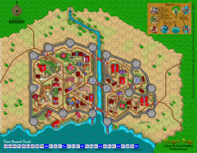
The combination of CD3 vector houses and bitmap symbols was just perfect to highlight the houses that serve as objectives in the game (with blue numbers).
The shading on the walls, trees and houses are on different heights and provide a realistic look to the map.
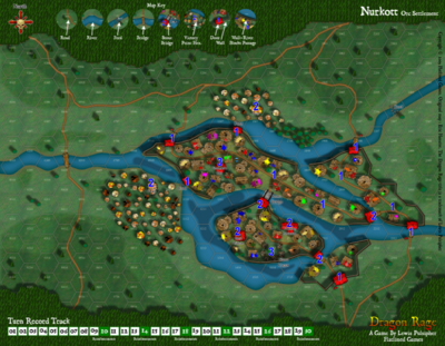
And here is the second map I created, Nurkott, an Orcish oppidum, attacked by Humans and various creatures :
You can learn more about Dragon Rage on the game page on our website .
We at Flatlined Games were so impressed by CC3 and CD3 that we placed a ‘mapped with Campaign cartographer’ logo on the box’s back 🙂
1 Comment
Simon Rogers | June 9, 2011 | review
There’s a review of CC3 over on PlayDevil.com 9/10.
Below is the first map that I made using the software, and it only took me about 20 minutes- a similar drawing in Photoshop from scratch would have taken me several hours!
“…for a budding cartographer there is nothing else quite like it out there. Once you have broken into the software, creating a good standard of map becomes not only easy, but a pleasure, as you behold your beautiful creations, which can be made quickly and simply.”
Comments Off on Review of CC3
Simon Rogers | May 12, 2011 |
Ralf created this map with Cosmographer 3 for Pelgrane Press’s forthcoming SF game, Ashen Stars, now on pre-order.

1 Comment
Simon Rogers | April 8, 2011 | perspectives
We’d added sheared and rotated bitmap fills for Perspectives 3 support, and we’ve been working on a full set of Perspectives 3 symbols.


1 Comment
ralf | March 24, 2011 | User Websites
Check out the beautiful maps of the World of Torn created by Natalya Faden.

1 Comment
Simon Rogers | March 21, 2011 | city planning
Location, Location, Location
by Steve Davies
Cities are one of the greatest environments for RPG adventuring. In a tight space, players can reasonably encounter every type of roleplaying challenge and meet each with a dizzying array of strategies and tactics. Cities can also be a gamemaster’s (GM) nightmare. It’s difficult to know where players will go next, detailed preparation is almost impossible, and everything should be available. To be successful, GMs need overall planning and a good city map. This series will get you started on the map and support your planning.
This is the first of a short series of articles on mapping cities for fantasy roleplaying games. I’ll show you the main considerations as you place, design, detail, and then play in the city. When we’re done, you’ll be able to draw out a reasonable city with confidence and present your players with an experience they won’t forget. I use ProFantasy’s Campaign Cartographer as my main mapping tool, and all of the maps are drawn with it. There is no post-processing on any of the maps.
I recommend that as you build your own city, that you keep a notepad at your elbow to record your thoughts and designs. Mapping is a creative process, and you will find that you generate many ideas for future adventures as you create your maps. Write the ideas down, and transfer as many of them to the map itself as you can. That way you can find them when you need them. So if you’ve just mapped a narrow pass that would be perfect for an ambush, add that encounter idea as a “GM-only” hidden note. If you don’t write them down in the moment, it’s often tough to remember or recreate the ideas later. And it’s great to be preparing for a gaming session and pull up the notes as a way through creative blocks. You will find that in city building, these notes are critical to make the city come alive later.
About Cities
Cities in the middle ages were rare. Fewer than a dozen true metropolises existed before the modern era. That is because a city needs the following things to grow and flourish:
- Abundant food and water to feed the population
- Water access: Either a navigable river or seaport
- Defense: Hills, river bends, and offshore islands all protect the riches of the city.
- Trade routes: Trade is the lifeblood of the city and where routes meet or goods transfer, cities grow.
The first task for anyone mapping a city is to find a suitable site for the city. On the map below, I’ve mapped the most likely places for a city to grow:
 Continue reading »
12 Comments
Simon Rogers | March 17, 2011 | city planning
Urban Planning
By Steve Davies
 If you’ve read our previous article, Mapping Cities 1, welcome back. If you just joined us, look at that first article, or just follow along from here. So far, we’ve found a place for the city, determined its size and laid out the general geography and boundaries.
Next, we’re going to add details to work up to an overview map of the city.
Major City Features
First, we need to place the major features of the city: Points of interest, major districts, entry points, roads, and other trade points. I generally cycle through these one by one, and continue going through the list until I am out of ideas. I’ll place these items on the map as labels or symbols to guide my further development. Here are some design considerations:
- Points of interest: This includes major buildings like courthouses, temples, and markets. Include government, business, religious, and entertainment points of interest. Usually a city will have all four types.
- Major Districts: I usually put in roughly one district per 1,000 people in the city. Wealthier districts take up more space (they are less dense). Put in labels for the districts if you have ideas, or leave them blank. The more affluent districts will be at the center of the city and along the major thoroughfares.
- Walls: Walls are expensive to build, but cities are valuable. Put in walls if the city is threatened, and expand the city outside the walls if there has been a period of peace.
- Entry Points: There should be a gate in the wall, or other way of collecting tolls, for every major direction from which people will enter the city.
- Roads: Roads will tend to parallel rivers and natural harbors; they will follow contours and attempt to rise evenly. Ridges will push the city into a longer form, often with a castle or temple at either end of the main street. On round hills, buildings cluster on top and roads tend to ring the hill.
- Trade: The city will thrive on trade. Make sure there are enough markets to cover everything for sale. But, don’t mix the cattle market in with the flowers, or even worse, ceramics and glass.
Continue reading »
2 Comments
Simon Rogers | March 15, 2011 | perspectives
The paladin lies vanquished by that indomitable foe – time.

1 Comment
