Location, Location, Location
by Steve Davies
Cities are one of the greatest environments for RPG adventuring. In a tight space, players can reasonably encounter every type of roleplaying challenge and meet each with a dizzying array of strategies and tactics. Cities can also be a gamemaster’s (GM) nightmare. It’s difficult to know where players will go next, detailed preparation is almost impossible, and everything should be available. To be successful, GMs need overall planning and a good city map. This series will get you started on the map and support your planning.
This is the first of a short series of articles on mapping cities for fantasy roleplaying games. I’ll show you the main considerations as you place, design, detail, and then play in the city. When we’re done, you’ll be able to draw out a reasonable city with confidence and present your players with an experience they won’t forget. I use ProFantasy’s Campaign Cartographer as my main mapping tool, and all of the maps are drawn with it. There is no post-processing on any of the maps.
I recommend that as you build your own city, that you keep a notepad at your elbow to record your thoughts and designs. Mapping is a creative process, and you will find that you generate many ideas for future adventures as you create your maps. Write the ideas down, and transfer as many of them to the map itself as you can. That way you can find them when you need them. So if you’ve just mapped a narrow pass that would be perfect for an ambush, add that encounter idea as a “GM-only” hidden note. If you don’t write them down in the moment, it’s often tough to remember or recreate the ideas later. And it’s great to be preparing for a gaming session and pull up the notes as a way through creative blocks. You will find that in city building, these notes are critical to make the city come alive later.
About Cities
Cities in the middle ages were rare. Fewer than a dozen true metropolises existed before the modern era. That is because a city needs the following things to grow and flourish:
- Abundant food and water to feed the population
- Water access: Either a navigable river or seaport
- Defense: Hills, river bends, and offshore islands all protect the riches of the city.
- Trade routes: Trade is the lifeblood of the city and where routes meet or goods transfer, cities grow.
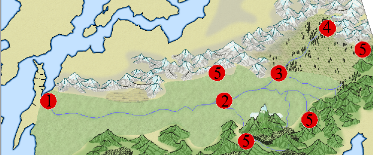
The first task for anyone mapping a city is to find a suitable site for the city. On the map below, I’ve mapped the most likely places for a city to grow:

