Urban Planning
By Steve Davies
 If you’ve read our previous article, Mapping Cities 1, welcome back. If you just joined us, look at that first article, or just follow along from here. So far, we’ve found a place for the city, determined its size and laid out the general geography and boundaries.
Next, we’re going to add details to work up to an overview map of the city.
Major City Features
First, we need to place the major features of the city: Points of interest, major districts, entry points, roads, and other trade points. I generally cycle through these one by one, and continue going through the list until I am out of ideas. I’ll place these items on the map as labels or symbols to guide my further development. Here are some design considerations:
- Points of interest: This includes major buildings like courthouses, temples, and markets. Include government, business, religious, and entertainment points of interest. Usually a city will have all four types.
- Major Districts: I usually put in roughly one district per 1,000 people in the city. Wealthier districts take up more space (they are less dense). Put in labels for the districts if you have ideas, or leave them blank. The more affluent districts will be at the center of the city and along the major thoroughfares.
- Walls: Walls are expensive to build, but cities are valuable. Put in walls if the city is threatened, and expand the city outside the walls if there has been a period of peace.
- Entry Points: There should be a gate in the wall, or other way of collecting tolls, for every major direction from which people will enter the city.
- Roads: Roads will tend to parallel rivers and natural harbors; they will follow contours and attempt to rise evenly. Ridges will push the city into a longer form, often with a castle or temple at either end of the main street. On round hills, buildings cluster on top and roads tend to ring the hill.
- Trade: The city will thrive on trade. Make sure there are enough markets to cover everything for sale. But, don’t mix the cattle market in with the flowers, or even worse, ceramics and glass.
Streets
I like to lay out the major roads early. The main things to think about here are terrain, connecting major points of interest together, and the amount and type of traffic. This latter is important to determine how wide the road should be. And remember, the homeowners on either side of the road will tend to crowd into it unless there is a strong controlling power. So only put in smooth, straight roads if city leaders can enforce and protect the road space.
Having major town roads that are 50’ wide is not unusual, and the streets could be wider if merchants drive cattle or other large beasts along them. Commerce will take place in the street, with vendors setting up awnings and booths to attract the passers-by, so the street scene will be unlike most modern cities.
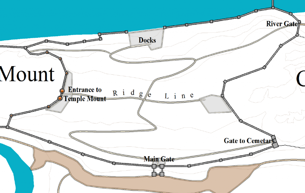
This city, Templeton, is predominantly a religious center. So I wanted a processional way that led from the main gate up to the temple mount. As I looked at that, I liked it so much I thought I’d add a similar one to go down to the docks. I decided that I wanted to have strong encroachment on the roads. Putting a single road along the top of the ridge completed the major processional planning:
I still need to put in the smaller roads, side streets, alleys, and all the places where interesting things happen. But I will add these as I detail the districts. For now we are just getting the overall structure of the city in place.
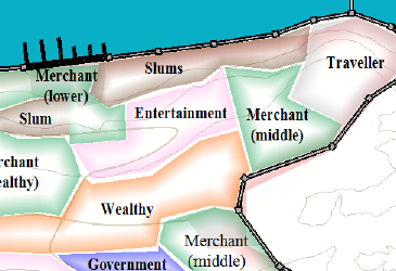
You can see below that I’ve put in some places of interest and colored the different districts. I usually leave those colors in place for later – it makes it easier later to see where one ward starts and another leaves off. Ideally, I want to know or have an idea where each of the major pieces of the city will go:
- Political: Courthouses, meeting halls, legislative bodies, and ruler’s palaces. (Blue).
- Wealthy: The powerful elite usually cluster in the best areas. (Orange)
- Manufacturing: If there are specialties of the city, it’s good to know where these will be at the start. Dangerous or smelly trades, like fireworks production or tanning, will often be outside the walls, and never in the upper class parts of the city. (Dark Green)
- Religion: Temples, religious councils, shrines, and other holy places are critical for any city. (Yellow). In Templeton, religious power is geographically concentrated in Temple Mount.
- Artistic: If there are street performers, they can appear in the market. But more established arts need theaters, galleries, and museums. (Purple)
- Military: From the town guard to navy, army, and overall militia, military units need to live and train somewhere. (Red)
- Education: Most cities attract a university or other high-level place of learning. (Orange)
- Commercial: In addition to markets, place specific trades. In medieval cities, often tradesmen band together in one specific part of the city. (Lt Green)
- Entertainment: Whether it’s chariot races, gladiator arenas, or parks for leisurely strolls, the people will need a way to relax and celebrate. (Pink)
- Slums: I usually include these as their own ward. Almost every city has them, where people who are struggling to survive live. Some will leave the slums to work elsewhere in the city, and others will earn a legitimate (or not) living in the slum. (Brown)
For other areas I use grey, and I leave white the areas that I haven’t decided on. If there are two similar districts next to each other, I often combine them into a single larger ward. Sometimes I will put a divider in the middle (to divide social levels).
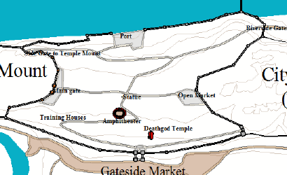
After a few passes through, here are two views of the city:
This is just an early view. Before I finish, I put in known inns and taverns, famous merchants, mad fortunetellers, and anything else that strikes my fancy. Often the map becomes crowded with text. I use Campaign Cartographer’s ability to zoom and hide to keep everything orderly.
One thing to keep in mind is that cities rarely grow following an overall plan. We will talk more about this when we detail the districts. For now, it’s just useful to think a little about the character of each district and what it might be like.
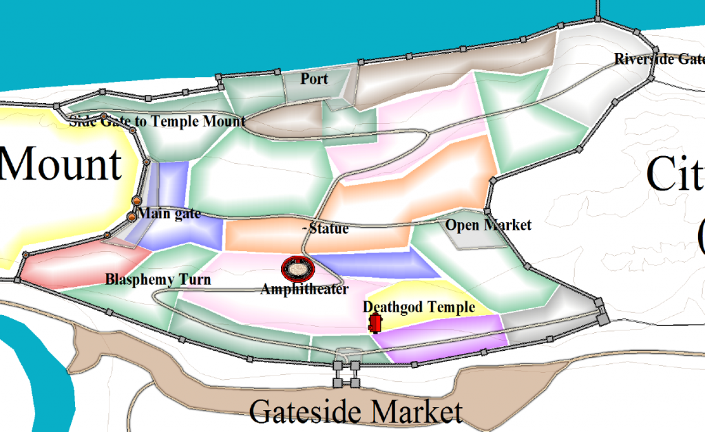
Here is what we have so far:
As you can see, my layout of the roads interacts pretty strongly with my drawings of the districts. That’s not unusual for me. I’ll usually do a couple of passes through the map, adjusting roads, adding new places of interest, and adjusting the wards, until I have something that works. With Campaign Cartographer, it’s easy to adjust things as I go.
I’m almost done with my planning. I’ve placed the major roads, and also included a few side roads where I thought they should be. I haven’t included every alley and building yet, but that will come in the next version of the map.
I’ve also put notes into the map to remind myself of key points for later. For instance, there is one place that the major processional road narrows and goes around a tight turn as it heads uphill. Everyone will have to slow at this corner, and I can imagine processions piling up and crowding at the point. So I labeled it “Blasphemy Turn” as the name by which the locals know it. In a future article, we’ll show you how to convert all these text labels into a table of links that will take you directly to that part of the map.
If You Can’t Decide
Relax. City building is rarely clean. There is usually a kind of logic to a city, but for every logical rule for laying out a city, one can readily find exceptions. Here are a few of my rules-of-thumb:
- Markets generate lots of traffic and taxes for the city. If there is space, markets should be inside the city. If space is at a premium (as in Templeton), put markets outside, starting with the livestock market, which needs space and is messy.
- Put political buildings in the power center of the city.
- Low-value manufacturing will flourish where living is cheap (outside the walls and in lower parts of the city); high value manufacturing that is clean (like jewelry production) will flourish in nicer areas. Locate smelly manufacturing (like tanning) as far away as practical.
- Religions that are in power will be in the center of the town. Religions out of favor will be on the outskirts or banned completely.
- Arts & entertainment can go anywhere, with their character matching their surroundings.
- Military buildings might be in the center of the city, but more likely tied to fortification or other points of strategic importance.
- Commerce happens throughout the city, with merchants often living above their stores.
If none of this helps, wait to determine where most things are. Put in a couple of monuments, or a key building or two, and stop. You’ll have many chances to come back to add detail later.
Gaming Check Point
You now have a high-level map of the city. It has all of the major attractions, it has the major districts of the city, and it has the major roads. It makes it easy for you to answer questions like, “Where’s the Senate building?”, or “Which road do I take to the castle?” You could give this map to players whose characters are new to the city. This is also a map you can use when characters ask someone to describe the city or tell them what it’s like.
In short, the information on the map so far should be common knowledge for anyone who’s been in the city for more than a few days.
So take a minute and look at the map. Does it have the things that players will ask for? Is it clear?
If you haven’t put names of points of interest (and maybe even if you have), it’s probably worthwhile to put a legend on the map. That will give you an easy reference when someone asks about a place of interest.
Final Planning
At this point, the city is starting to take shape. We have most of the major points of interest placed. We know where the walls, roads, and districts are. We know the lay of the land and what we need to map.
It is worth thinking a little bit now about the character of the city and what will make it unique.
The beliefs and culture of the inhabitants of a city determine its character. If the people are inwardly or family-focused, city blocks will shut out the outside world and face inward toward courtyards and family areas. If the people are group-focused and outwardly focused, family houses and blocks will provide ample access and visibility to passersby.
The strength of the city’s government will also determine the form and structure of its streets. Every property-owner has an interest in expanding his property, and one tempting way to do this is to expand into the street or over the street. If city government is not strong, streets will become increasingly narrow and overhung with second floors that extend over the street.
If you’re following along, you probably have a good-looking map already. Hopefully, you also have a file full of adventure ideas. In the next article, we will begin detailing a district, to put your great ideas on the map.
The City Mapping Series
Part 1: Location, Location, Location
Part 2: Urban Planning
Part 3: Laying out Districts
Part 4: Districts in CC3
Part 5: Sizing Buildings
Part 6: Filling Blocks in CC3
Part 7: Houses Galore!
Part 8: Outside the Gates


A lot of nice ideas, thank you for this. 🙂
I’m glad you like the article!