[Ed: Bill Roach is best known in the CC3 community for creating the free Terraformer enhancement to Fractal Terrains 3. Here he turns his attention to water courses; a features which is often added to maps without much thought.]
A PDF of this article is available
(Images in this article not created by the author are either courtesy of the EPA, FEMA, USGS, or NOAA, or are licensed as Public Domain, or under the GNU Open Document License by their respective authors.)
The rivers on your overland maps will be the life blood of your simulated world. Most of the plant and animal life on your maps will cluster next to them, near them, and around them. Settlements, towns, and cities will grow alongside them, and fishermen, hunters, trappers, farmers, and merchants will depend upon them for their livelihoods. They will act as major arteries of commerce, major zones of cooperation, and points of contentious, sometimes vicious geopolitical dispute. In peace they will be places of celebration – and in war, they will be places of intrigue. They will be signposts for travelers, and form the borders of nations. They may even be the focus of religious pilgrimage. They will be some of the most important and essential key elements of your maps.
When you design your overland maps, also remember that your riverways, lakes, and seas will influence weather.Agriculture depends upon rain – and farms are typically found in water rich places. Rivers and lakes mean farms, farms lead to hamlets, villages, and towns, towns give rise to cities, and cities give rise to nations.
In the real world – human civilization first began in earnest along a region of several vital river valleys known as the Fertile Crescent.
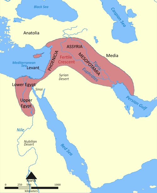
The Nile, Tigris, and Euphrates rivers were key to the birth of some of the very first Neolithic agricultural communities. It is in this region – somewhere in what is now Iraq – that the Garden of Eden is rumored to have been located. It is also here where the first true city states were born. Most of the world’s major religious movements began here.
The empire of Hammurabi (ca. 1728 – 1686 B.C.) occupied nearly the entire zone. It is here that the foundations of civil law were first devised – a set of laws and torts known as The code of Hammurabi. It is for these reasons that the area is often referred to as The Cradle of Civilization. Trade and commerce by waterway first began here by moving goods by river boat up and down the Tigris and Euphrates rivers. The first seafaring merchant and naval fleets allegedly began here as well. Most of the goods that we trade today are shipped by sea – and water has been, and always will be vital to the survival of any civilization.
Rivers come in a wide variety of shapes and sizes, and there is really no set rules on what a river should look like. Two rivers located only a few miles apart and both situated in a North to South path , might in fact flow in opposite directions. Only three factors govern where and how a river will flow:
#1, GRAVITY,
#2, TERRAIN SURFACES AND ELEVATIONS ALONG ITS COURSE,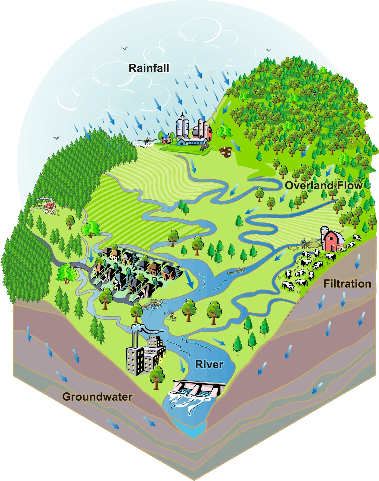
#3, QUANTITY OF AVAILABLE WATER.
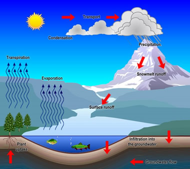
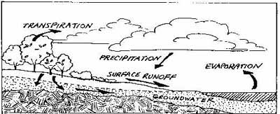
A river by definition is only a quantity of water, flowing downhill, following a path of least resistance. The abundance of water that a river has to work with depends in large part upon a process called The Hydrological (Water) Cycle. It’s just a fancy name for the way that water first evaporates at lower elevations where it has collected – turns into rain, hail, or snow via condensation and transport – and then – the water precipitation falls over the higher elevations – again – causing it to flow back downhill across an irregular surface (above and below ground level), following gravity and a path of least resistance, to finally recollect again at the same lower elevations that it came from.
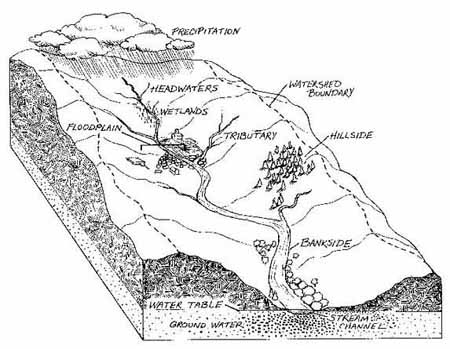
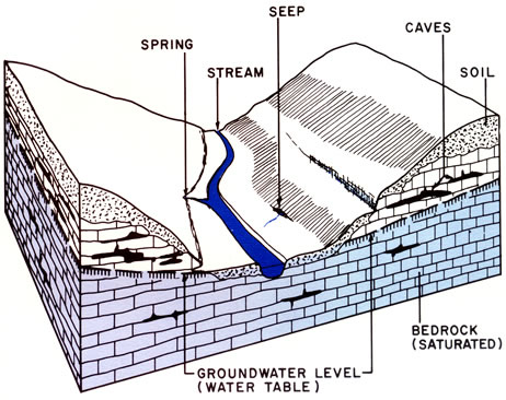
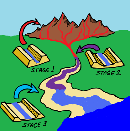
The point at which a river begins is called its headwaters, and is situated at the highest elevation along its course. A river valley is actually a watershed system – where water drains from higher to lower elevations. The river depicted in the above graphic might be a small river with tiny creeks and brooks draining into it from higher elevations, or it could be a major river like the Mississippi river with lesser rivers draining into it – again – stemming from gradually higher elevations. The principles of a watershed system are universally the same despite its scale.
A watershed system might be as small as drainage water running downhill from someone’s front lawn into a street gutter, or it could be as massive as an entire continental river basin containing a complex network of large rivers emptying into a single giant mega-river. It really doesn’t matter. It all boils down to simply describing how water flows in a downhill pattern.
You should understand from this explanation, that when you are planning the river systems for your maps – it is perfectly logical for you to portray them as running from a single mountain, a mountain range, a plateau, or a series of foot hills, as this is in fact the standard model for a pretty typical river system. Rivers always flow in a downhill direction. Rivers are typically located at the transitional slopes of higher to lower elevations.
The basic anatomy of a watershed / river valley system is given in the above graphic.
The entire watershed system fuels local ecosystems. The watershed is the frame work for all life within any ecological climate zone.
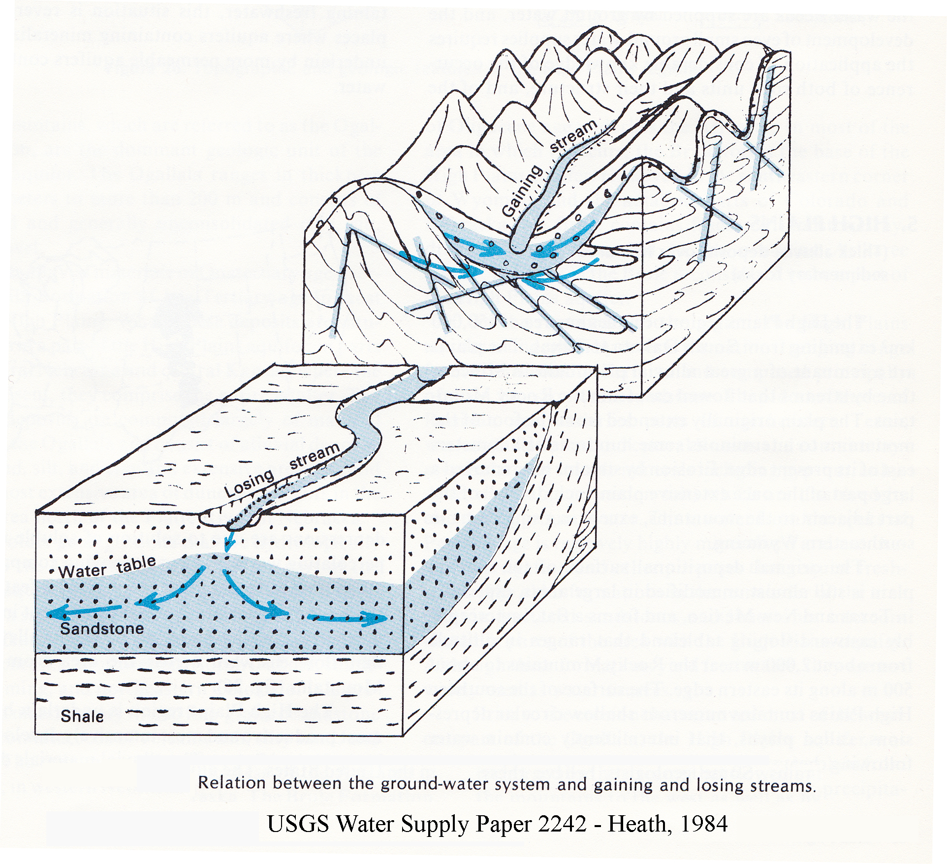
Within a classical watershed / river valley system – as water flows down from mountains or higher rocky elevations to the lower elevation plains – it typically moves from an environment where the river tributary will GAIN water due to pooling over rocky, shallow surfaces, to an environment where it will lose water due to ground soaking via loose, granulated combination soils. Water flows more rapidly the higher its elevation, and slows down as it approaches lower elevations due to gradual water loss because of ground soaking, and because of a gradual leveling of its course which reduces the effects of gravity on the water currents. It is in the lower elevations when the river becomes a losing stream as opposed to a gaining stream, that more water will be returned to the environment. River rapids are more common in transitional elevations between the flatter lossy river plains, and the higher rocky lossless terrain, where the river flows over broken transitional foundation rock.
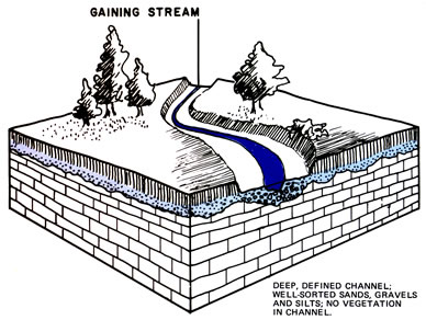
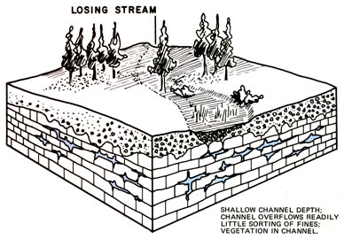
Gaining streams are found traversing rocky terrain – generally at the higher elevations of the watershed / river valley system. Losing streams are generally found at the lower elevations of the watershed / river valley system. Losing streams are the zones where water is returned to the ecosystem more abundantly.
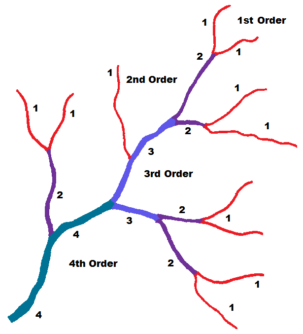
The above is a stream order diagram of the structure of a typical tributary network within a watershed system (river basin). A river system can have any number of forks and branches – but it always starts at a first order tributary stage (headwaters – labeled 1 on the diagram). The streams labeled with a 1 are at the highest elevations of the network, and in this particular case, the part of the network at the lowest elevations are labeled with a 4. Wetlands, marshes, or swamps could be located at any stage of the river – but are most likely to be found at the lowest stages of the river network (4) within its Floodplains. Streams labeled 1 are gaining streams, and those labeled with a 4 may become losing streams as the river system changes over time.
A Floodplain is a region that is often situated at the lower elevations of a watershed system – at the forks of tributary branches – and along the river itself. It is here where flooding is most likely to occur because – during periods of heavy precipitation, or during periods where glacial snow at higher elevations melts too rapidly – more water enters the Floodplain zone than can either flow out of it along the main river channel, or be absorbed into saturated ground soils. Wetlands, marshes, and swamps are commonly found situated in and around Floodplains. These are more specifically areas at the forks / branch origins of the river tributaries, and at the widest sections of the river’s course.
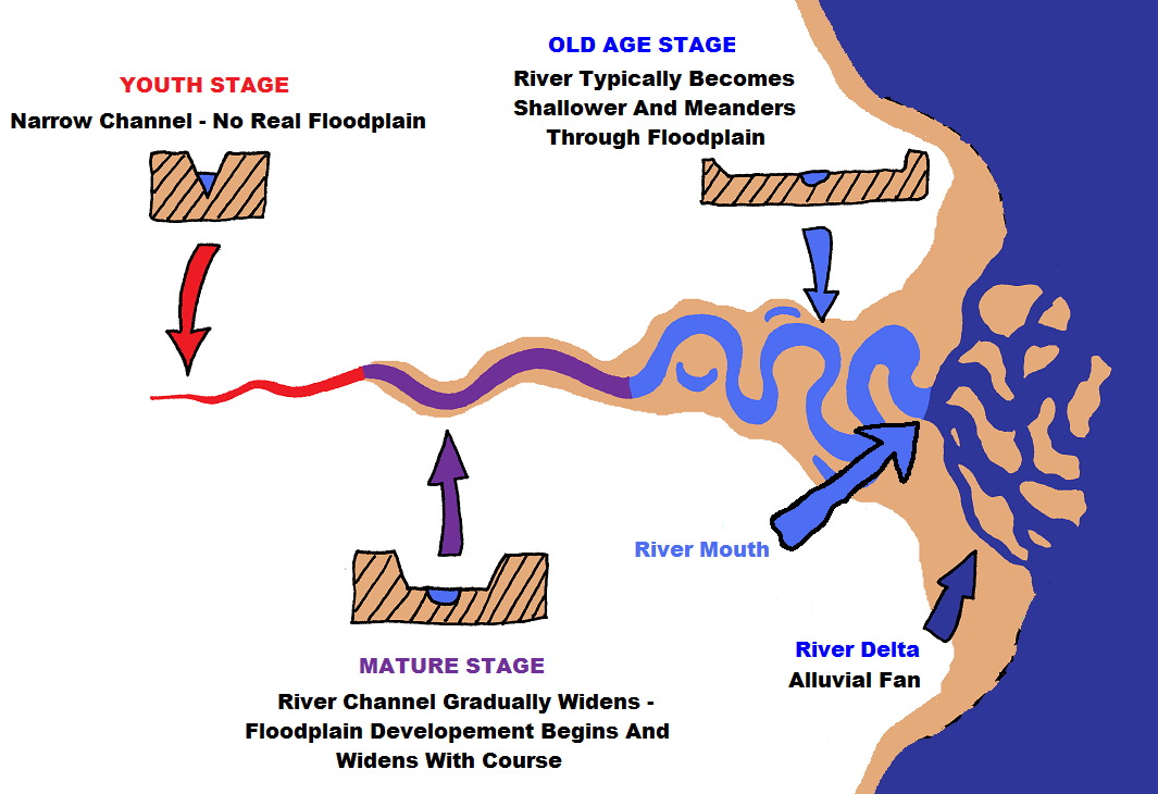
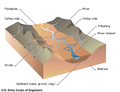
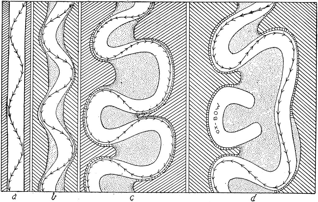
A river has three basic stages of development as it travels down its course, these are the Youth stage, the Mature stage, and the Old Age stage. These names are not meant to represent actual chronological ages, but they only denote the evolution of the river as it travels. The river begins as a narrow, fast flowing stream, and it eventually ends up as a much wider, slowly flowing, meandering mess with a typically frequently snaking course – confined within the boundaries of a much wider, more dominant Floodplain. The above graphic is a model of the basic structure of a river system within a watershed.
A river doesn’t have to end at a delta, and it does not have to empty into a lake or a sea at its mouth. Some rivers are Isolated Waterways, in that they do not connect to other streams or rivers – or empty into ponds, lakes, or seas – but instead – end by fanning out into smaller creek and brook systems that eventually fade out, they flow into hidden underground aquifers, or they simply spill out into a dry spillway, where their waters soak into the ground sediments and disappear. Many river systems are orphans, having neither a parent river – nor child tributaries – but simply flowing and stopping more or less somewhat like a dead end road. The longer that a river’s length is – the longer the span, and higher the frequency of its meandering patterns towards the end of its course. The width of its flood plain will gradually widen from being nearly non existent in its youth phase – to being several times wider than the width of its channel at old age.
Rivers are not static entities – they do change over time. The most frequent cycles of change over time occur farther down the course of the river away from the youthful stages of the river network system. Changes do occur at the source and headwaters – but usually at a much slower pace. As a river flows over terrain – it changes that terrain – and readjusts itself to flow with as little resistance as possible.
Canyons can be formed by ancient river systems as they wear away stone and soils.
Meandering rivers can also cause soil erosion due to ever expanding Floodplains. The very thing that feeds an agricultural community – can also be the very thing that eventually could cause the land to become unfarmable due to topsoil loss from run off and frequent flooding.
Bare in mind that although a few communities located near wide Floodplains where frequent flooding occurs will be die hard, choosing to stay put and stick it out, many other communities, however, will uproot and relocate – staying near the river but moving to areas not as prone to flooding along its banks.Ghost towns and submerged partial structures and under water abandoned roadways are often found in and around major Floodplains, marking the former locations of extinct towns or uprooted communities.
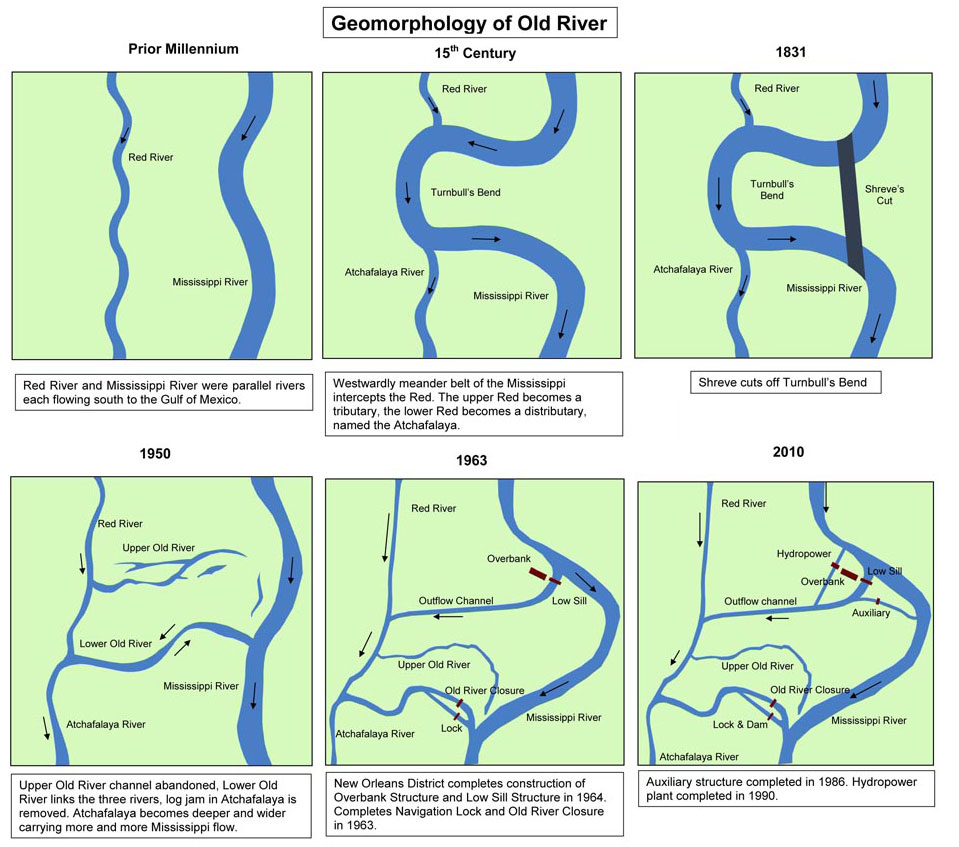
The above graphic depicts how rivers in the latter mature to old age stages (lower elevations) can change due to periodic flooding across surface terrains – causing new terrain surface morphologies due to soil and silt movement and shifting. This is an area of the New Orleans district showing the changes in the Mississippi and Red rivers over roughly a thousand years.
In the above graphic, two separate parallel rivers have evolved over time into a braided
system. Here – in some areas – multiple rivers can share the same Floodplain. It is in zones like this that you will likely find dense forests, swamps, and marshes.
When you are designing areas like this on your maps where there are tightly clustered and interconnected mature and old river systems – any habitations close to this type of river network will be subject to frequent flooding – especially in lower areas. These will also be areas with dense forestation.
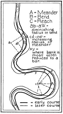
In this graphic (above), you can see how a river’s course can change over time. In this case the shore lines are gradually worn away due the direction of the currents, causing the river to begin to meander, and causing its Floodplain to widen. Typically this happens as terrain elevations within a watershed system become more equalized, or leveled out due to geological changes over time – or when available water for a river system decreases due to climate change, and its overall length begins to contract towards its source.
When this happens the river channel itself becomes shallower – and the overall Floodplain widens out. Instead of a consistent river flow rate with little variation – you have a river that has widely changing seasonal depths where it has periods where it might be almost a dry river bed – to periods where it is a raging, turbulent river. As a river shortens or lengthens over time – its average current strength along its mature stage increases – wearing away more shoreline – either further shortening it with serpentine bows, or increasing its length with wide meanderings. In the continental United States – this pattern happens typically in the western half of the continent due to gradually decreasing source water, and in the eastern half of the continent due to terrain surface changes as a result of frequent flooding.
Note the above illustration showing the proportional widening of the Floodplain per stage of the river course. This is a key thing to remember. As any river network moves from higher to lower elevations – it is moving away from a surface environment that is mostly rocky – to moving towards a surface environment that is much looser and granulated, and more diverse in the varieties of ground soils present.
When you are planning your maps – your forests and your marshes, swamps, and wetlands should be situated in and around the Floodplains at the Stage 2 and Stage 3 zones for more realism. They will grow denser / more numerous and more widespread and scattered as the vegetation patterns follow the contour of the river course towards the mouth of the river. If you will be placing forests close to swamps on your maps – then you will place your swamps in the Floodplains (right up against the river – or have the river flow through a swampy area). You should then place your forests so that they hug the outer edges of your swamps.
The Hydrological Cycle, or The Water Cycle, works when there is enough available
moisture to keep it going – and thus – keep the river(s) within a watershed system (a drainage valley) going. Moisture not only comes from the areas where water has pooled from previous rains (from the rivers themselves, as well as from stationary water sources like lakes), through Evaporation, but from the plant life that flourishes around that water source, through a process called Transpiration.
The more abundant the plant life, the more abundant the available moisture there will be to be freed up for atmospheric condensation. The more moisture that there is that is available for condensation, the more potential precipitation there should be (in frequency and / or abundance), and thus – the more water there should be that eventually will be returned to the river system. The frequency and amount of that precipitation depends upon the availability of thermal lift from daytime surface heating, and the concentration of solar radiation affecting that specific watershed system. This is where the climate zone comes into play, and it is the reason why some watershed systems fuel prairies, while others feed rain forests.
The key to the Hydrological Cycle is heat. The climatological location of a river valley / watershed system determines the frequency of condensation and precipitation due to heat, or more accurately, the presence of thermal lift, and heat induced atmospheric destabilization. These factors determine how much plant life will thrive within, and cling to the lower elevations of the river valley.
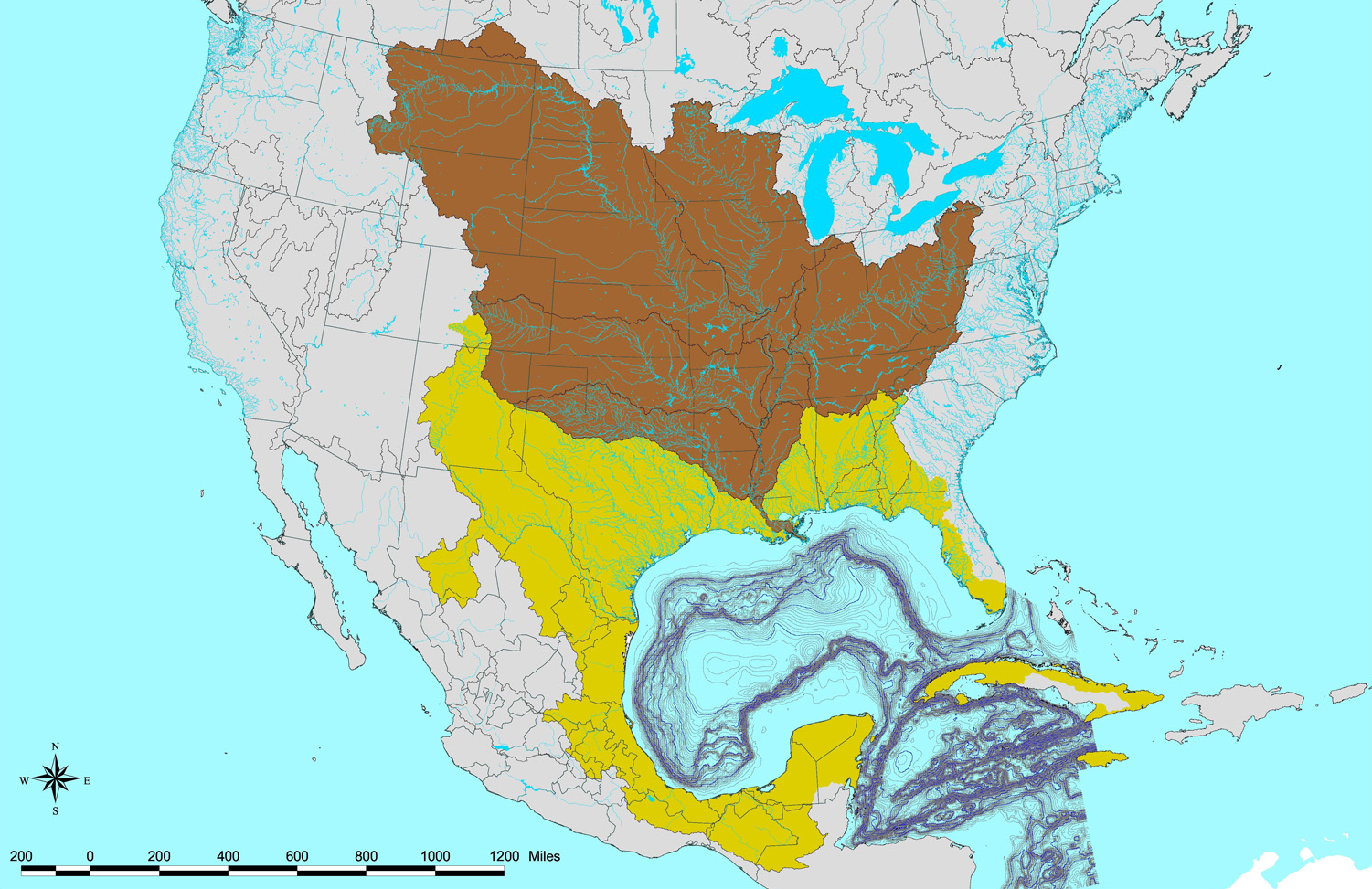
The Mississippi / Missouri Rivers basin system is a compound river valley system incorporating roughly 30% of all of the major rivers and waterways in the continental United States, (brown areas indicated in the above graphic). It is actually one huge river valley comprised of multiple, smaller river valley systems that empty into the Lower Mississippi River. The Missouri River Basin has the highest elevation in the system, and the Lower Mississippi Valley has the lowest elevation within the system.
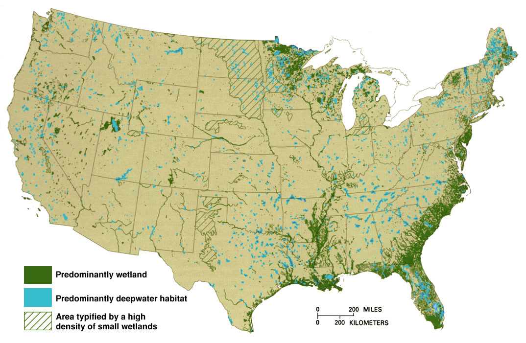
Topographical maps of the continental United States are excellent models to look at in terms of how watershed systems work – because this region is unique for being almost perfectly set up to demonstrate the interactions of elevation, precipitation, and ecology. If we look at a map of the distribution of U.S. wetlands (i.e. marshes, swamps, bog lands, etc.), We can plainly identify the locations of major Floodplains. These Floodplains are directly related to ELEVATION. These are regions of most abundant water flow concentration – where most of the water within the system pools up before emptying into the Gulf Of Mexico. These are also areas with frequent precipitation because of the abundance of surface moisture from the ground due to flood waters and abundant plant life – and greater moisture transport coming in from the Gulf Of Mexico, due to southerly wind patterns across the lower elevations and the blocking effect of the higher elevations to the west of the Greater Mississippi Basin.
These are important phenomena when considering where to place marshes, swamps, and wetlands on your maps. Barring underground springs or hidden water sources – your wetlands, marshes, and swamps will be located in Floodplains at the lowest elevations of river / watershed systems, as well as the shallows of the coastlines of lakes and seas. Also – it is important to note that river valleys within warmer, wetter climate zones will have a higher abundance, and denser distribution of large swamps and bog lands per square unit of land area at lower altitudes approaching sea level, at zero altitude, or below sea level.
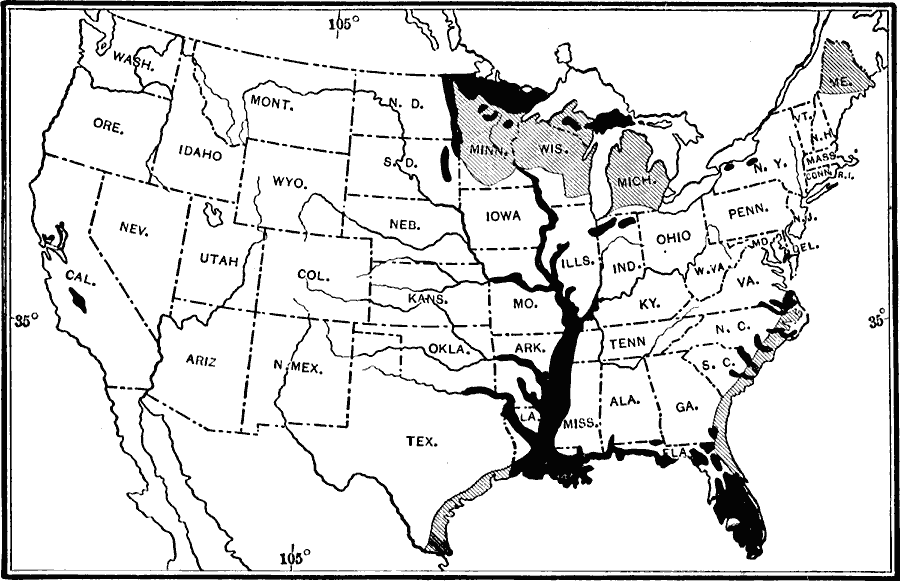
This graphic (above) depicts swamplands (black), and moderate wetlands (hatched areas), as they were surveyed in 1911 for the lower 48 continental United States. Note how the dense swampland distributions cling to the Mississippi river – and widen out, proportionally increasing with the gradual decrease in the elevation of the Mississippi River’s total course.
When we consider how the Hydrological Cycle works, we understand that the shapes and elevations of your terrains on your maps will tell you exactly where to put your rivers, and where – and how – you should logically distribute your forests and swampland.
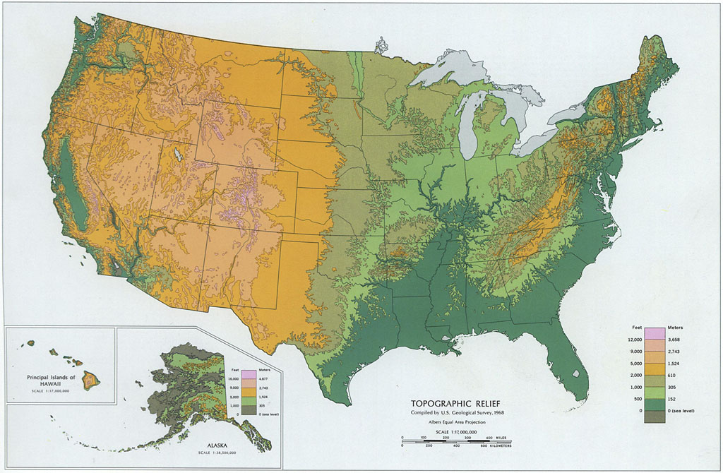
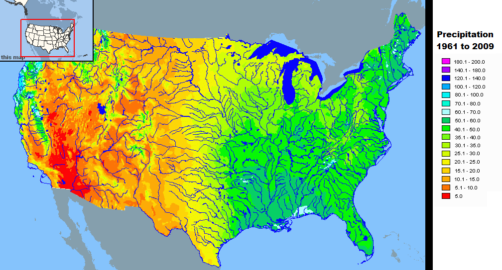
The above two maps demonstrates the relationship between elevation and weather, and where the highest concentrations of watersheds (river valleys) are located within the continental U.S.. The top map is a topological elevation map, and the bottom maps shows all precipitation for the lower 48 states between the years of 1961, and 2009. It is plain to see the Hydrological Cycle in action here.
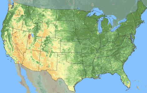
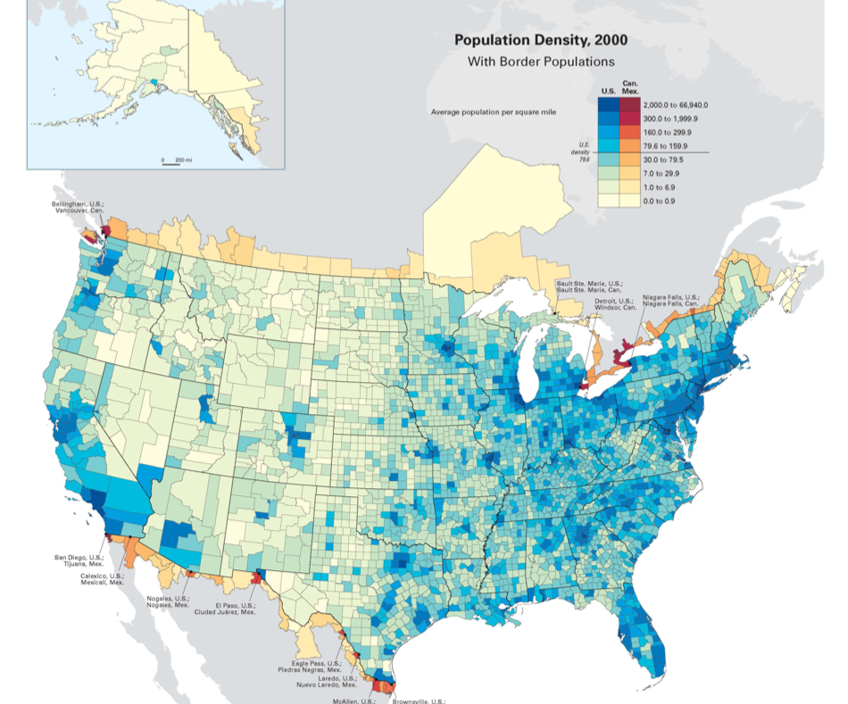
Now let’s look at two more maps. The top map in this pair shows the distributions of vegetation across the continental United States at the peak summer month of July for the year 2005. The bottom map shows human population densities across the continental U.S. For the year 2000.
Note that in the above map, the urban and agricultural areas are distributed across the lower elevations. Wells are dug at lower elevations because it is much easier to do so where the soils are richer, and subterranean geological rock strata layers that can interfere with digging can be avoided more tenaciously. Ground water tables beneath the ground are far more accessible at lower elevations where it is less rocky, and the soil is more moist and loose.
That is not to say that farms do not exist in mountain terrains – they do – but farming such landscapes requires land development operations that are typically more expensive labor and resource wise – because they require not only tilling the land – but reshaping it as well. Lower, more level terrains are also more travel friendly, requiring much less energy to get from one location to another. Communities spring up where the environment is more easily exploitable, and where the landscape can be more easily modified.
So – in summary – here are the Rules Of Rivers.
#1, Rivers always flow from higher to lower elevations.
#2, Wetlands, swamps, and marshes are generally found in flood plains.#3, Floodplains are generally found where rivers are thickest, and where they branch out – and in the shallows of lakes closest to the shoreline.#4, Rivers are thickest – and branch out – in areas of uniform lower elevation in comparison to the surrounding terrain – typically in the lowest regions of valleys, or areas that are generally flat or depressed terrain.#5, Warm, humid areas will have more swamps and marshes than any other – irregardless of whether or not they (other areas) fulfill the prior criteria – due to greater rain fall.
#6, There are really no set rules on where a river will begin or end – but generally the longest and widest rivers (like the Mississippi river, The Amazon River, The Brazos River, The Nile River, The Danube, etc.) – either start, end, or start AND end at delta spillways into larger lakes, seas, and oceans.
#7, Most of your vegetation distributed on a given land mass will be associated with an adjoining body of water, i.e. Forests and swamps will be most numerous and dense along and around rivers, streams, ponds, lakes, and coastal sea shores. Wetlands, Marshes, and Swamps are often found at the forking areas / branching origins of multiple river systems that connect or branch off of each other – and along / atop the shallowest areas of freshwater seas, lakes, and ponds in locations along shores that are nearest dry land. #8, Civilization LOVES water. Towns, cities, hamlets, villages, settlements, and camps will nearly ALWAYS be close to some kind of water source. Human civilization first began next to a river. The more geopolitical boundaries (political borders) a body of water intersects – the more settlements will be situated near it as a trade artery. The largest / longest body of water within any political division will have the highest concentration of civilized settlements (more accurately – POPULATION) within that division.