ralf | September 11, 2025 | Exploration, historical, history, Portugal
 Earlier this year I was in Portugal, hiking on the Rota Vicentina or the Fishermen’s Trail. It’s a great coastal hike with beautiful towns, stunning cliffs and amazing beaches, but it is also an area of special interest for us map-makers. Fraught and problematic as the following era of European colonization and exploitation is, there is no denying that one of its starting points was here in Portugal where sailors and explorers set off to go beyond the edges of the maps – and hopefully get rich and famous in the process.
The Fisherman’s Trail starts just a bit south of the town of Sines. It’s not a big tourist destination and more important as an oil terminal nowawadays, but it is also the birthplace of Vasco da Gama, the first European to reach India via the sea route around Africa. His statue overlooks the bay and harbour of Sines today.
I stopped in Sines on my way back to Lisbon after the hike and took the opportunity to visit the excellent little local museum in Sines’s castle.
 While pondering the history of the town and the voyages of its most famous resident, it occurred to me that this kind of exploration – finding new routes to important destinations – is one that lends itself very well to our kind of hobby. The map – and the process of creating a map – is the focal point of the activity. In a way, the map IS the plot of a grand adventure. I’ve played in role-playing game campaigns, where the player characters were members of a grand expedition to reach the other side of the world, past enemies and obstances who were blocking the easier, existing routes.
So, if you ever find yourself in that part of the world, I recommend not speeding by the seaport of Sines, but stop, take a break and visit the birthplace of Vasca da Gama, whose successful voyage certainly played a part in shaping the following centuries.
Leave a comment
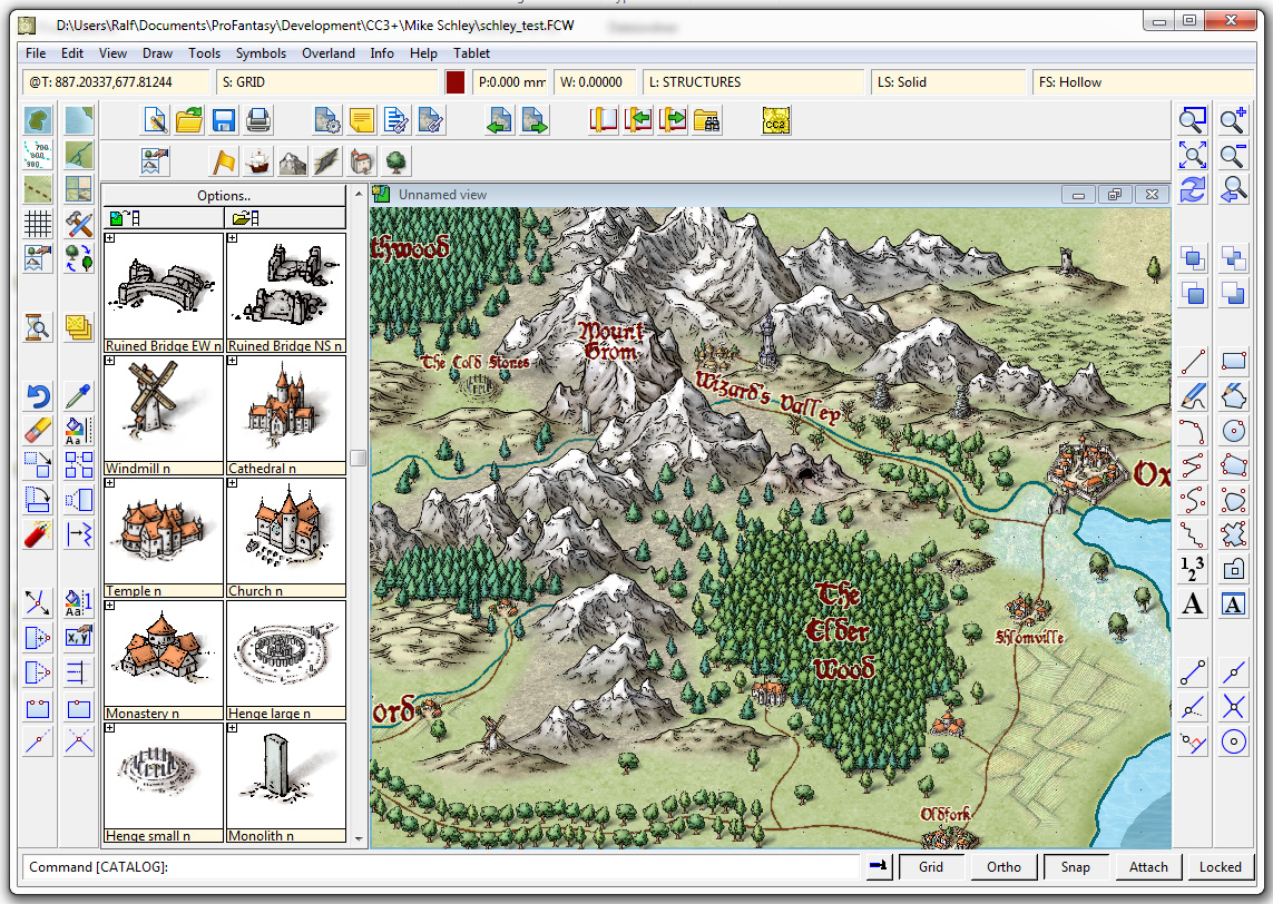
Simon Rogers | January 14, 2014 | cartographers, CC3, CC3 Plus, development, history, Mike Schley
CC3+ incorporates a new complete symbol set from expert cartographer Mike Schley. We’ve worked with a number of professional cartographers to create Campaign Cartographer styles, and the process is now pretty slick. We are either adapting an existing style (as with our recent World War 2 annual issue) or creating one from scratch. This is the process:
1. We take a cartographer’s existing map, or the cartographer develops a new map style, always by creating a small map sample. Here is an early one Mike Schley produced for the new CC3+ overland style.
2. Once we’ve approved this, the cartographer adds more symbols and tools to the example map, and then does more as stand alone files. For a full ad–on or symbol set, this is a very big job. Usually the cartographer works in Photoshop, with layers on, so we can easily extract elements to create CC symbols and drawing tools.
3. Once the map-maker has finished, Ralf duplicates the style in CC, developing the set of drawing tools and adding effects to match the original.
4. Ralf creates the full set of symbol catalogs in all resolutions, with varicolour areas.
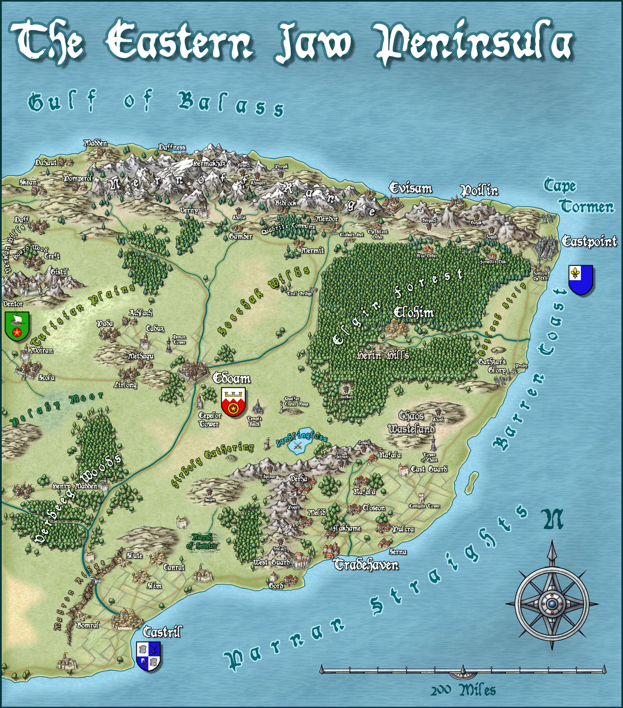
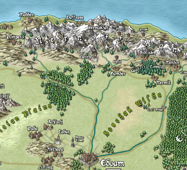
The very first example map we did with Campaign Cartographer was of my campaign setting, the Jaw Peninsula, and we intend to continue this tradition with CC3+. You can see the history of the map here and Ralf has rendered the eastern section of the map in his new style. Click the image for the full high-resolution map.
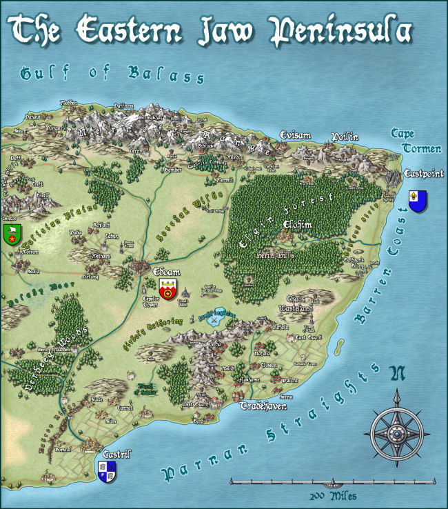
And here is a close up
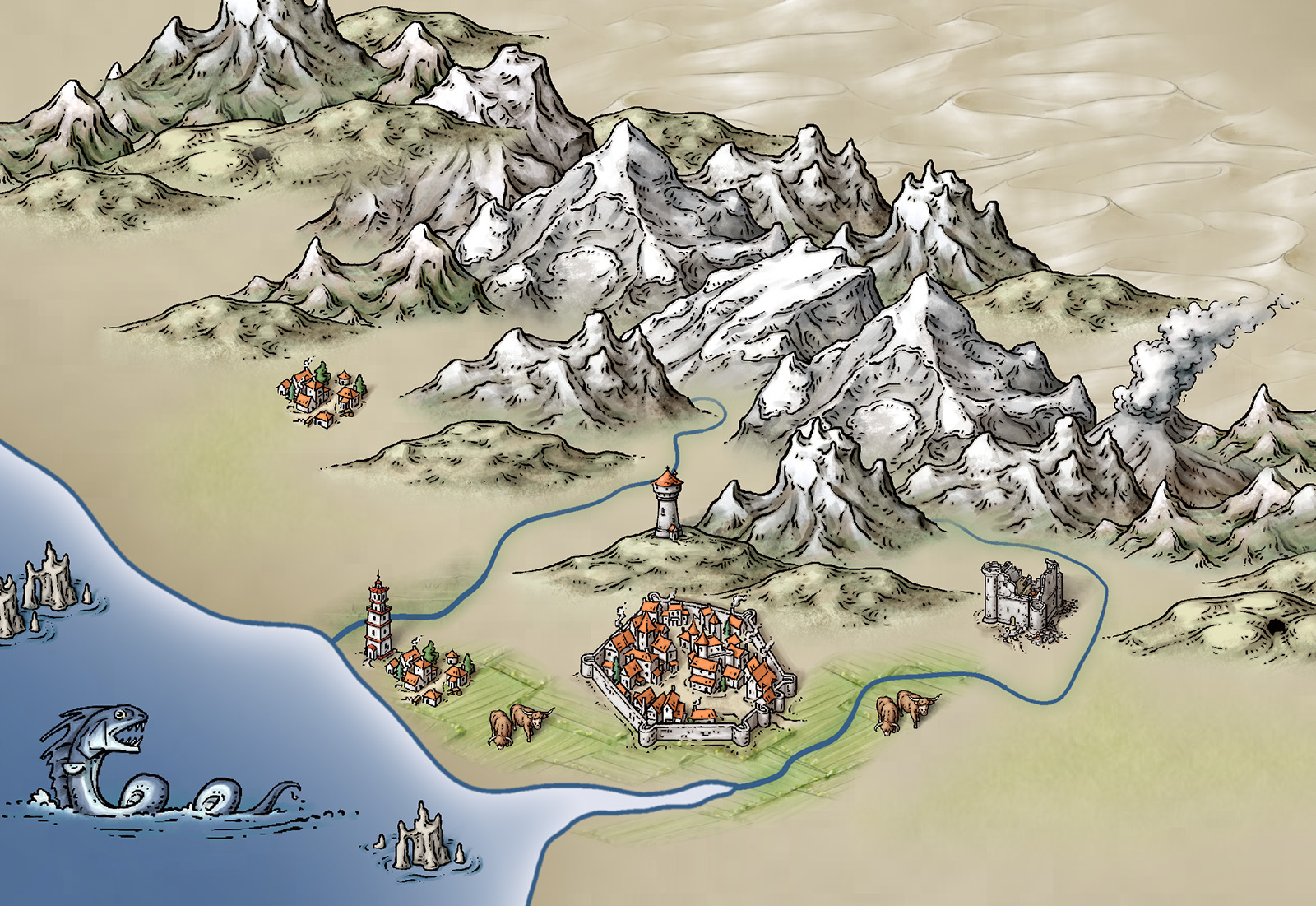
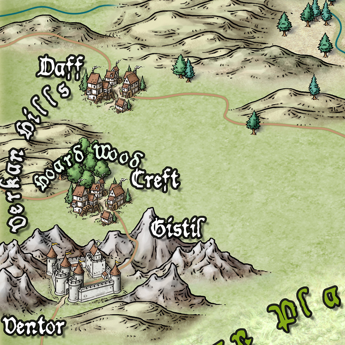
And just to give you an idea of how detailed the symbols are – little works of art – here is a close up. Click for extreme close up.
2 Comments
Simon Rogers | February 21, 2013 | history
Mark Fulford and I formed ProFantasy Software back in 1993. At that time, Mark sold CAD systems (computers with pre-installed software) and I had just finished university. We are both keen gamers, and the idea of combining Mark’s knowledge of CAD with roleplaying to create campaign maps was attractive. The difficulty was finding a CAD program which was even vaguely close in price was the main problem. Enter Mike Riddle, creator of AutoCAD and later FastCAD and EasyCAD. He was willing to take a risk on us, allowing us to have a license to FastCAD at a price which enabled us to resell it to gamers, and only 200 or so licenses all told. We simply removed dimensioning, an essential feature for CAD designers, but not so important for gamers.
Over the years Mike has rewritten the software for his customers, but also taking into account our customers and ideas, improving the interface and functionality for both standard CAD users and cartographers. Next week, for the first time, Mark and I will be visiting Mike in person out in Phoenix, partly to come with new ideas for the next version, but mainly because we’ve never met despite long conversations and creative endeavours over nearly 20 years. One other person who worked with FastCAD is Peter Olsson, who then created most of the code for our add-ons and added buckets of functionality to the core program. Peter has worked in the ProFantasy offices and also with Mike in person, and he’ll be joining us.
It’s a long-delayed meeting, and I’m looking forward to it.
[STOP PRESS: Mike Schley, who has created a new overland style for CC3+ lives in Phoenix, and we’ll be meeting him to discuss future cartography projects.]
Related Sites
4 Comments
Simon Rogers | October 8, 2010 | history
Back in the early 80s, I began my long-running AD&D campaign set in the Jaw Peninsula. I drew a map which slowly disintegrated, and which Mark Fulford (my now business partner) copied it out by hand, adding new details. When we started ProFantasy, this was our target map for the original Campaign Cartographer for DOS. The difficult thing initially was to get trees and mountains looking decent, and the discpline of printing only to a monochrome dot matrix helped here. This was created with line art, using the 16 colours then available:

With CC Pro for DOS we added raster fill styles which enabled us to stretch the 16 colours available into a range of shades:

Then we moved onto the Windows 95 version, which gave us the chance to redo the symbol set with a wider range of solid colours.

Up to this point, it was me, a non-artist who was doing the cartography. I asked Ralf to redo the map using the Fantasy Worlds style from the Annual 2009.

Here is a close up. This map saw service recently in a mammoth weekend session of AD&D, and I have a feeling that CC3 may need some more example maps…

8 Comments
 Earlier this year I was in Portugal, hiking on the Rota Vicentina or the Fishermen’s Trail. It’s a great coastal hike with beautiful towns, stunning cliffs and amazing beaches, but it is also an area of special interest for us map-makers. Fraught and problematic as the following era of European colonization and exploitation is, there is no denying that one of its starting points was here in Portugal where sailors and explorers set off to go beyond the edges of the maps – and hopefully get rich and famous in the process.
  While pondering the history of the town and the voyages of its most famous resident, it occurred to me that this kind of exploration – finding new routes to important destinations – is one that lends itself very well to our kind of hobby. The map – and the process of creating a map – is the focal point of the activity. In a way, the map IS the plot of a grand adventure. I’ve played in role-playing game campaigns, where the player characters were members of a grand expedition to reach the other side of the world, past enemies and obstances who were blocking the easier, existing routes.